|
Surveying Thailand | |||||||||||||||
|
Last update: Nov 21, 2023 Surveying and mapping Chiang Mai and Thailand.
The railway survey from Burma to Chiang Saen.
By Archibald Colquhoun and Holt Hallett.
In 1879 Archibald Ross Colquhoun and Holt Hallett were early western visitors to Chiang Mai. They were by no means the first travellers to visit Chiang Mai; the missionaries were well ahead of them. In 1867 the First Presbyterian missionary expedition was made by the McGilvary family. It was called the "North Laos Mission", since Chiang Mai and Lanna were not yet part of Thailand. Dr. Daniel McGilvary built a wooden church on the East bank of the Ping River, close to the Nawarat bridge. It was the first Western building in Chiang Mai, and is still there, now owned by the aptly named First Church of Chiang Mai.
An even earlier visitor was Captain William Couperus McLeod (also W.C. MacLeod); who arrived in Chiang Mai on January 12, 1837. The very first westerner though was Ralph Fitch, an Englishman who visited Zimmé (Chiang Mai) in 1587.
Archibald Ross Colquhoun and Holt Hallett were colleagues studying and reporting on a proposed railway connecting British Burma with China. Holt Hallett, a retired railway engineer, was tasked with mapping a route for this railway. He wrote the book "A Thousand Miles on an Elephant in the Shan States" in 1890, and this is still an excellent source of historic information on Northern Thailand.
The other route went from Moulmein northwards, crossed into Thailand to Mae Sariang, east to Hot, northeast to Chiang Mai, through Chiang Rai and ending in Chiang Saen. Hallett returned to Bangkok to seek Siamese support for the railway; and his meeting with King Chulalongkorn (King Rama V) was a success, "the King expressed himself strongly in favour of the railways". However, Hallett’s proposed trans-Asian railway never materialized, largely because the British wanted Moulmein as the terminus, not Bangkok.
The people of Thailand were most interested in Western technology like railways, but always managed deftly to keep the colonial powers of Britain and France away from their territory. If they were building a railway it was on their terms; and it went not from Moulmein but from Bangkok to Chiang Mai. In 1901 Thailand started the construction of its own railway from Bangkok; which was to reach Chiang Mai in 1921. The rulers of Thailand never saw a need for a railway to Burma, but the Japanese army tried to build one in World War 2. They succeeded in making the "Burma railway", also known as the also known as the Death Railway, at a great loss of life of British, Australian and Dutch war prisoners. The effect of the Burma railway on the war was very limited, since the amount of goods transported was very little. After many decades of isolation, Myanmar has opened up its land borders in 2013; and nowadays, the most popular border crossing is at the towns of Myawaddy (Burma) and Mae Sot (Thailand). That is right where Hallett planned the railway from Moulmein to Tak. The Myawaddy - Mae Sot border has also the largest trade volume of all Myanmar's land borders. The two moustachioed colleagues wrote the following two books about their surveys in the Siamese Shan states, where Siam is the old name for Thailand:
Both books are exploration books; written in the same period and style. Holt Samuel Hallett's book is mainly about surveying possible railroad routes and has detailed maps; Archibald Ross Colquhoun's book is more about the people and tribes of Northern Thailand, sometimes in exhausting detail. They both have colourful descriptions of markets, clothing, and habits of the Southeast-Asian population at the end of the 19th century. In a sense these books are the forerunners of modern travel blogs and books. Both Archibald Ross Colquhoun and Holt Hallett were not just "railway men", but also amateur anthropologists. For example, Archibald describes that, quite surprisingly, at that time there was still widespread slavery in the Siamese Shan state. A quote from "Amongst the Shans" :
(Page 70)
In most of the Karen-nee villages, "Shan-yangs" of the Karen tribes, Yendalines, and Padaungs, of the mountain- ranges to the north-west, are found, all doomed to a hopeless state of slavery, into which, priced like beasts of burden, they are sold to the Zimme Shans, by whom they are re-sold to the Siamese.
(Page 257):
Slaves are bought in Zimmé as elsewhere in Indo China, the average price for a woman, provided she is under forty-five years of age, being about 72 rupees (£6), while that of a man, the inferior animal, is about 54 rupees (£4). These "slaves" however had the ability to leave and change masters whenever they chose to, this prevented undue hardships being imposed upon them. The name slave is perhaps not accurate says Archibald, quote: (Page 185): Slavery is hardly the term that should be used for the bond-service that is found in Burmah, Indo-China, and the Malay Peninsula. The indebtedness of the people, which is the principal cause of more than one-third of the population of Siam being in bondage, arises from three causes: heavy taxation, gambling, and indolent improvidence (lazy and lacking foresight). The debt-bondage arises from the heavy rate of interest that is given for loans; as much as six percent a month is sometimes charged for the first three months, after which time the rate is reduced to three per cent.
A 1000 Miles on an Elephant - surveying Thailand
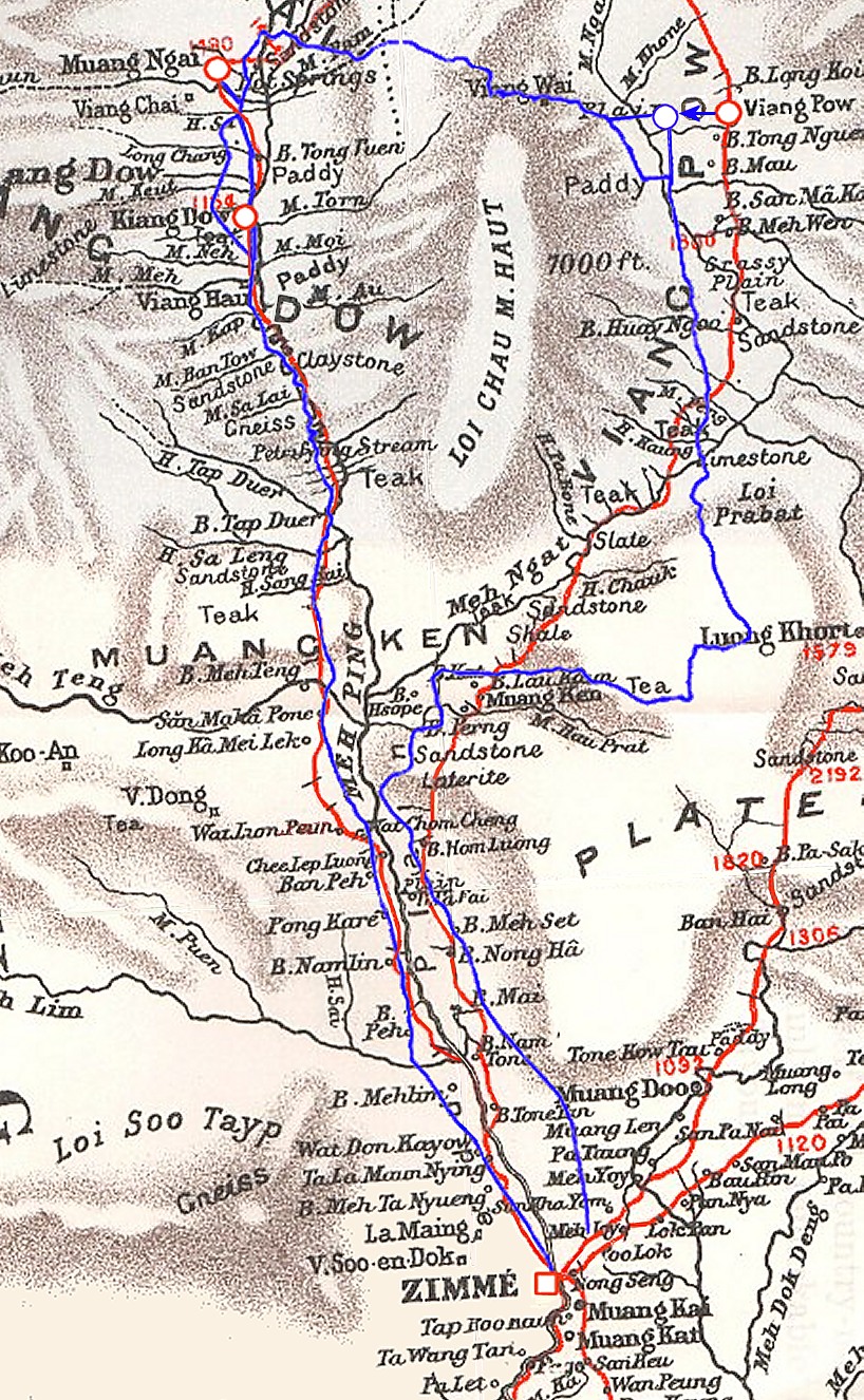
Holt Samuel Hallett estimated his location with a compass and by observing the walking speed of his elephants; he went up north from Chiang Mai to Chiang Saen and back via another route. When the Royal Geographical Society's cartographer plotted his survey; he found that Hollett had calculated his location wrong by less than 2 kilometres. The cartographer was quite surprised about this "highly satisfactory result". Maybe this was a bit of luck, for example Viang Pow on the map is the old name of Phrao, on Hallett's map it is offset by a few kilometres. At the time Holt Hallett was writing his book, published in 1890, another man was already surveying Thailand with more advanced equipment and methods. James McCarthy was using triangulation to survey Thailand; a much more accurate surveying method that measures the angles in a triangle formed by three survey control points. James McCarthy, who created Thailand’s first accurate maps, worked as Government Surveyor from 1881 to 1893 for the Royal Survey Department of Thailand. He published a book in 1900 about the survey of Thailand:
The dangers James McCarthy and his men endured resulted in the production of maps and surveys which were used for the planning for Thailand’s railway network. Unfortunately, McCarthy visited many towns in Shan state and Laos, but did not describe the town of Zimme/Chiang Mai in any detail. He seemed to have liked the small town of Luang Prabang (Laos) a lot, since he devoted a few chapters to it.
|
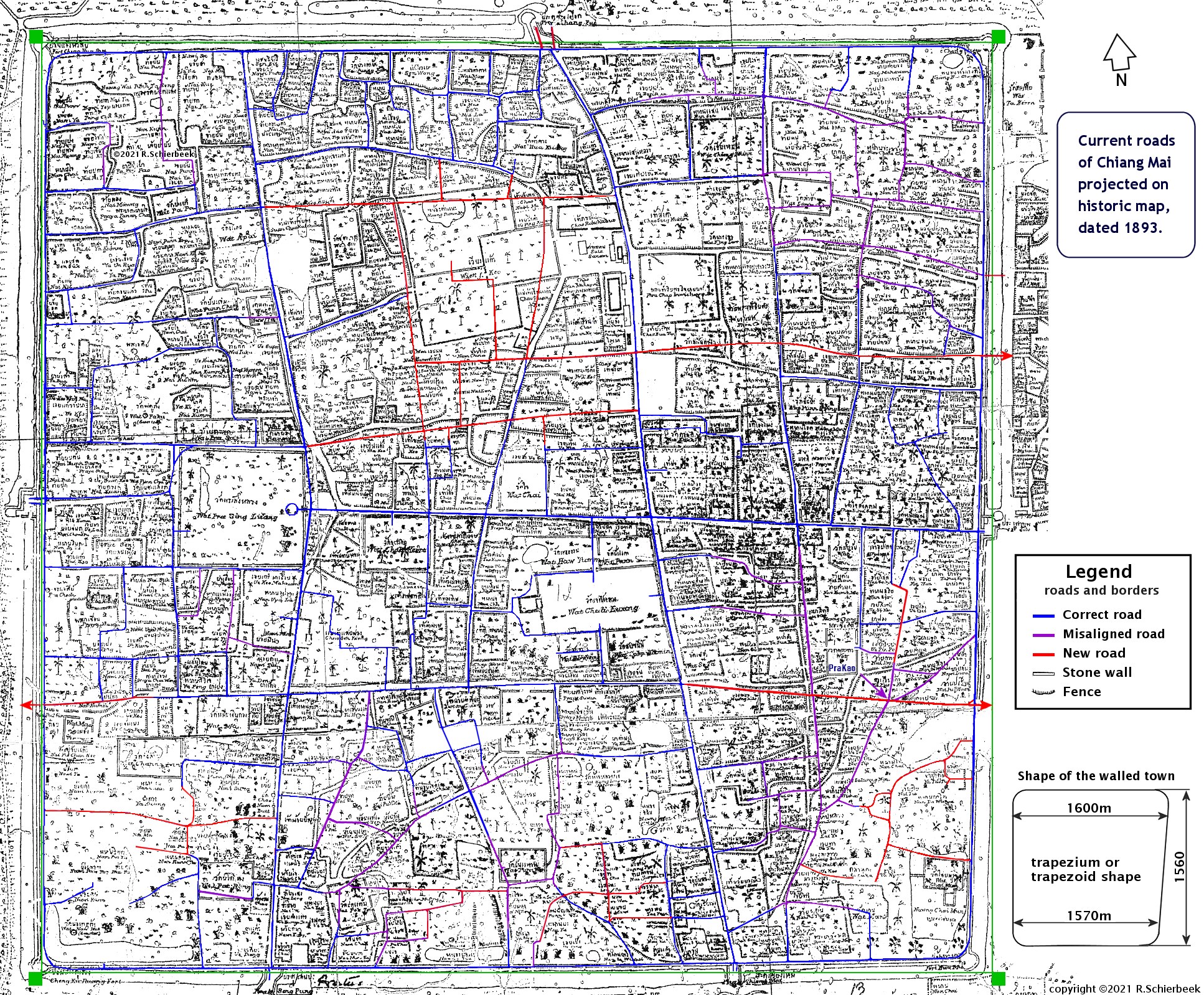
Surveying Chiang Mai in 1893.The walled town of Chiang Mai was not a perfect square, but is often described as a rectangle. I would like to suggest that it is more of a trapezium (or trapezoid) shape, since the southeast corner is clearly off. On the map the green lines outline perfect square. The surprising fact is that the map-makers have drawn this trapezium shape of the town very accurately. The northern wall is 1600m wide, the southern wall is 30m less long, a difference of 2 percent.
The accuracy is hard to comprehend, when they made so many errors elsewhere. For example, in the SE-corner, someone drew Wat PhaKhao in the wrong spot, on the west side of an alley where it really was on the east side. The streets around it were also shifted about 80 meters to the northwest. But overall, they managed to measure the streets of Chiang Mai quite precise. The surveyors probably had access to a theodolite, after all, this instrument was not a recent invention. The "Great Theodolite", which weighed approximately 200 pounds, was constructed 2 centuries ago in 1782. James McCarthy, who created Thailand’s first accurate maps, worked as Government Surveyor from 1881 to 1893 for the Royal Survey Department and used theodolites and triangulation. It is possible that the professional surveyors measured the moat-roads and main roads, and some of the many alleys were measured by approximation. Perhaps a junior employee was assigned to survey the SE-corner, and misplaced Wat PhaKhao on the wrong side of the road. The inaccuracies in some spots are very surprising, but we can only guess at the reason. The town of Mandalay, founded in 1857, is a precise square with walls of 2032m by 2032 meters. Mandalay is a relatively "modern" town, with a street plan based on a grid. Chiang Mai was created many centuries earlier in 1296, and has irregular streets, very different from the old Burmese square cities like Bago, Taungoo or Mandalay.
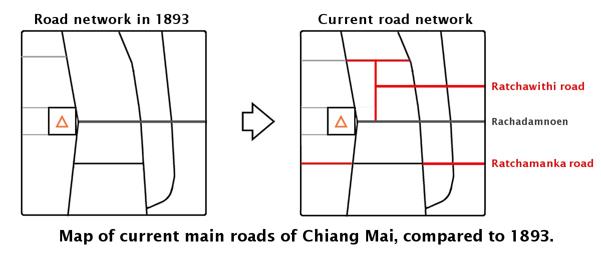
However, as is visible in the map, a few new east-west roads have been created in the beginning of the 20th century to improve the accessibility of the old town. This has created a more rational street grid. Two of these wide new roads are Ratvithi (Ratchawithi) road and Ratchamanka road, which run parallel to the central axis, Rachadamnoen road. During the Second World War Japanese troops demolished large parts of the city walls and used the stones for road construction. After WW2 the urban development of the old town continued, and the remaining parts of the walls were removed. This made room for a dual lane ring road on the inside of the moat. The outside of the moat got a similar two-lane ring road. The outside ring road now has one-way traffic in a clockwise direction, the inside is counterclockwise, and many U-turn places were created across the moat. It is quite sad that the old walls and gates were removed, but at least the four bastions and the moat remain. The advantage of the ring road is that there is relatively little traffic in the old town, and it is a very nice, walkable city, which also has plenty of room for bicycles. The busy outer road can be tricky for bicyclists, specially on the western side where there is a lot of traffic from the airport to the Nimmanhaemin area. To accommodate the increased traffic a few larger ring roads were created, the closest to town is the "superhighway". The many highways around town certainly make car traffic easy, and there are still very few traffic-jams around the town. The exception is the busy Huay Kaew Road, the primary road leading out of Chiang Mai to Doi Suthep. This road has many traffic lights along the way, one of which has a waiting time of up to 7 minutes! Quite surprisingly, the old town has only 5 traffic lights. The outside ring road has 3 traffic lights, and most car drivers choose to go around on the ring road, instead of taking the roads in the old town where one has to drive more cautiously. The one place that could use traffic lights is the outside ring road at Thapae square, where pedestian crossers have to wait or run for it to cross the road.
Historic development of walled cities in southeast-asia.Perhaps the best remaining example of a walled city similar to Chiang Mai is the Mandalay fortified city, which is a precise square of 2032 metres walls. This is such a large size that bicycling along these extended walls becomes quite monotonous, especially in the hot midday sun. Mandalay is also a relatively "modern" town, it was founded in 1857.
The royal palace was usually located in the center of town in Burmese square cities like Mandalay, Amarapura and Bago. In Chiang Mai though, the royal palace was a bit up north; and Wat Phra Singh was central. The main east-west street which leads from Thapae gate to Wat Phra Singh is the Ratchadamnoen road; which means Royal Promenade or Royal Road. The main entry to a city was usually at the eastern gate, the direction of the rising sun. Chiang Mai's temples are also oriented east-west, the entry on the east side, then a large main temple hall, and a large chedi (stupa) on the west side behind the main hall. To visit an ancient walled city, you could consider Angkor Thom in Cambodia; which is a huge fortified city with walls of 3km long, and about 800 years old. Angkor Thom was built around 1200 by King Jayavarman VII; and the famous towers above the 5 entry gates to Angkor Thom (the face gates) have his face on their four sides. The orientation of temples towards the east was not a hard rule, for example Angkor Wat's main entry is on the western side. Most of the other temples and palaces in Angkor Archaeological Park, like Angkor Thom and the royal palace have an entry on the east side.
Does Chiang Mai mean "New City"?Whereas Bangkok is less than 250 years old, Chiang Mai was founded in the late 13th century. Bangkok's city pillar was erected on 21 April 1782 when it became the capital of Thailand. Previously Ayutthaya and Thonburi were the capital; and Bangkok was just a small village on the Chao Phraya River. In travel guides the meaning of Chiang Mai is often explained as "New City", as opposed to Chiang Rai, which was the first royal city. But "New City" is not the complete translation for Chiang Mai. What is the origin of all the "Chiangs" in Northern Thailand: Chiang Mai, Chiang Rai, Chiang Dao, and Chiang Saen? Chiang is a Sino-Tai loanword, from Middle Chinese, meaning "fort, castle", and by extension, “city” (wikipedia). Chiang Rai was founded by King Mang Rai (nowadays spelled Mangrai or Mengrai); and Chiang Rai means "King Rai's City". In 1294 king Mangrai decided to relocate his capital further south, close to the current Chiang Mai town; and in 1296 the construction of the walled town of Chiang Mai began. Thus, a town was called "Chiang" if the king himself, or one of the higher-ranking royalties, lived in the town. A Chiang was a fortified and perhaps moated town with direct connections to royalty. Therefore, the simple translation of Chiang Mai may be "New City"; but perhaps a better translation would be "New Royal City".
|
|
Reference and links.
Background: aboutme Any comments or improvements? Please mail me at : bytelife AT gmail.com
“Do not go where the path may lead, go instead where there is no path and leave a trail."
All photos copyright © 2023 R.Schierbeek (except the historic black and white ones).
|
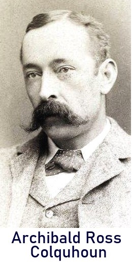
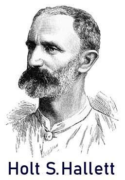 Archibald and his colleague Mr. Holt Samuel Hallett however were the first to describe the people and tribes of the Siamese Shan state (northern Thailand, also called the Lanna kingdom); at a time when it was an isolated area.
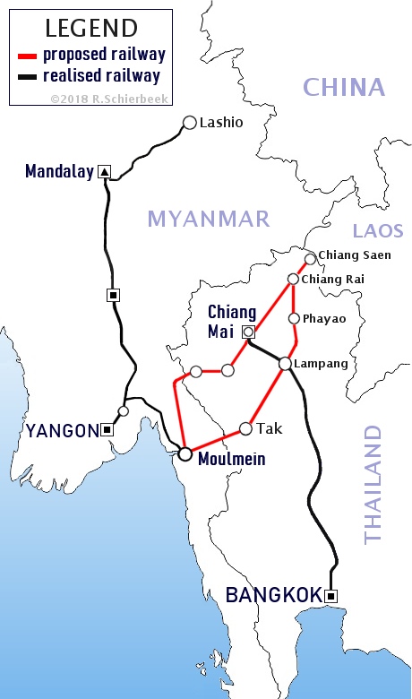 The railway line from Burma to Chiang Saen that Holt Samuel Hallett surveyed was never constructed. Two routes were proposed, both starting in Moulmein. Moulmein or Mawlamyine was the capital of Burma during British colonial rule from 1827 to 1852; thereafter Rangoon (Yangon) became the capital. The first proposed route would start in Moulmein, go into Thailand to Tak, then upwards towards Lampang, north through Kiang Hai (Chiang Rai) and ending in Kiang Hsen (Chiang Saen); the terminal point.
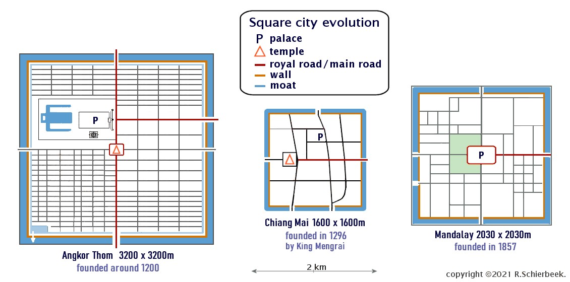 Historic development of square cities in SE-asia, Angkor Thom compared to Mandalay and Chiang Mai.