|
Thapae Gate | |||||||||||||||
|
Last update: Apr 7, 2024 In search of Thapae Gate.
Chiang Mai's walls and bastions.The fortifications around the old town of Chiang Mai were rebuilt by Kawila (Chao Kavila), after he liberated the city from the Burmese at the end of the 18th century. To defend against further attacks by the Burmese, he added bastions at each corner.
There are five gates in the four walls, clockwise starting from the northern gate: Chang Phuak gate, Tha Phae gate, Chiang Mai gate, Suan Prung gate, and Suan Dok gate. These gates are recent constructions made between 1966 and 1969; they do not resemble the original gates as depicted on King Inthawichayanon's map. During the second world war, the original gates and walls were demolished and used for road construction, and the re-created gates are very wide and sit aside modern roads. In many places road crossings of the moat have been added. More on the construction of modern roads here: Surveying Chiang Mai in 1893. The few remains of the wall at the four corners of Chiang Mai are not original. From 1996 to 1997, archaeological excavations were conducted before extensively renovating the remaining wall sections. These renovations involved a combination of old and new bricks to restore what was left of the walls. Unfortunately, only low walls near the corners of the old town remain as a result. In the winter of 2018/2019, a new large-scale renovation project began using new brickwork, making the restored portions of the walls and bastions clearly visible. The bastions located at the four corners and the moat are the sole surviving original parts of the fortifications. However, it should be noted that all of the bastions have undergone restoration multiple times throughout the centuries. For example, below is a black and white historical photograph of the Jaeng Sri Phum bastion in the northeast corner, which clearly shows its severely deteriorated state by 1967.
|
|
The Mystery of Thapae Gate - the Big Puzzle.Thapae Square is the centre of activities and celebrations in Chiang Mai. Chiang Mai revolves around Thapae Square, which is livelier than the Three Kings Monument Square in the middle of the old town. The large Three Kings Square does have two museums, but usually it is not the center of activities. The heart of Chiang Mai is the Thapae Square plaza. Chinese tourists love to feed the pigeons and make selfies; totally ignoring the large signs in Thai, English and Chinese to NOT feed the pigeons. Most of the tourists love to make selfies by the Thapae Gate sign on the fresh modern bricks. Been here, done that.
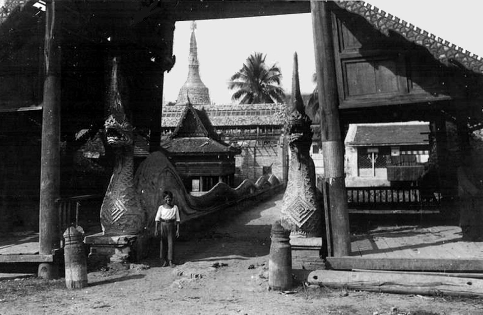
Most people on Thapae square have no idea about the authenticity of the construction of Thapae Gate. Anyone interested in old buildings, castles, history will spot that the perfectly straight walls are not ancient, but most people when asked guess it is from 200 years to 900 years old. The fresh red bricks are betray its age: it is very modern. Anyone reading the plaque will discover is a reconstruction from 1986. But most tourists just want to walk around the square and make a selfie, preferably with some pigeons, and aren't interested in the history of the walls and gate. Been there, done that. The Thapae Gate that you see at Thapae Square is a modern building from 1986. The gate is a contemporary reconstruction, very loosely based on an old photograph of Thapae Gate as it looked in 1899. The wall is built around a hollow concrete support structure, it is oversized and totally straight as if measured out with laser alignment equipment and modern tools. Therefore, the modern Thapae Gate has nothing to do with the original gate; the only part that looks like the original is the wooden door construction, which is designed to look like the doors on the historical photo. All the rest is a very contemporary piece of imagination. So its an instagrammable hotspot, but as far as history goes complete nonsense.
Next to Thapae Gate is a plaque which explains the history of the inner and outer Thapae gate; and which also states: "Based on a photograph of ONE of the Thapae gates". There used to be two gates on Tha Phae road, one in the square city wall, and one at the outer defense ring where Thapae Road crosses the Kamphaeng Din wall. (Kamphaeng Din) The name "Thapae" is a transliteration of a Thai word; and it can be spelled as Thapae, Thaphae, Tha Pae, and many other variations. The most common spelling is "Thapae".
The location of the original "Thapae Gate".For a long time, there have been doubts about the location of the original "Thapae Gate", where the photograph was taken in 1899. Was it where the modern reconstructed gate is now, in the square city wall; or was it at the circular outer defense wall, which was for a large part a high dirt wall with a small canal around it?
Thapae Gate was a double gated courtyard, a secure entrance to the walled town. On this site lanna-ww2.com all the ancient gates are described. Hak Hakanson makes the point that the photo of Thapae Gate in 1899 might have been located to the east of the current location; where Thapae Road crosses the outer circular wall. The Kamphaeng Din wall is indicated on the map below. Thaphae Road runs from Thaphae Gate to the Mae Ping River. Tha Phae translates to "raft landing"; in ancient times the Ping River was the main transport route. Let's have a look at the detailed map below from 1893; which was created in King Inthawichayanon's time.
The inner Thapae gate (1), or Prathu Thapae Nai, is on the left. The outer Thapae gate (2), or Prathu Thapae Nok is on the right; where Thapae Road crosses the Kamphaeng Din wall. Just outside Kamphaeng Din wall is a small canal, with two large ponds. Holt Hallett writes about these two entry portals as being courtyards made from stone walls in his book "A Thousand Miles on an Elephant in the Shan States"; but didn't describe the gates in detail.
The inner Thapae gate.If we look carefully at the wall in the background on the historic photo, it seems there are a lot of bushes and trees there, instead of houses and rooftops which one would expect inside the city. Let's have a look at the inner Thapae gate on the old map, and compare it with the situation now.
On the left is Thapae gate as it was drawn on the old 1893 map, with a small courtyard. On the right is a map of the old inner Thapae gate projected on current roads. The viewpoint from where the photo was taken would be at the crossing of Rachadamnoen and Moon Muang road. The old gate had a defensive round tower. The historic photo is not clear, but in the back behind the left figure there seems to be a large structure - perhaps the tower? However, there seems to be a problem. The offset between the 2 gates is quite large on the drawing, much larger than it appears on the photograph. Is it is possible that the photo was taken from the inside of the old city, looking eastward? The trees in the background are strange, there should be some houses there. Also, the offset between the gates could be about 10 meters. It seems difficult to make the photograph match the map.
Observations on the black and white Thapae Gate photo:
The outer Thapae gate.
There is a possibility that the photo was taken at the outer Thapae gate. Could the defensive courtyard and gates have fitted into the relatively narrow Thapae Road?
If we project the old map from King Inthawichayanon on the current roads and buildings it matches surprisingly well. With some resizing and tweaking the result is visible below. Thapae Road is 14 meters wide at the east side of the outer gate; which is 3 car lanes plus sidewalks, and the gate fits in like a glove. On the western side of the outer gate Thapae the road narrows to only 2 car lanes.
The Wat south of Thapae Road is the whimsical Wat Buppharam; the red-roofed temple buildings north of Thapae Road are Wat Saen Fang. Wat Saen Fang is a very old temple, going back to the 14th century; but most of the present buildings date from the 19th century. The viharn at Wat Saen Fang used to serve as the Ho Kham (palace residence) of king Chao Kawilorot, in the 1860s. The central white/grey square building in Wat Saen Fang is a Burmese-style chedi (stupa).
These walled temple areas fit reasonably with the map, because Wats were holy places which were rarely abandoned, unlike houses which could be sold and converted into modern buildings. The accuracy of the Wat Buppharam temple is a bit off, it is a trapezium (trapezoid) shape rather than a rectangle. The large ponds east of the gate were filled in and now have modern buildings on them. The canal has been straightened; but the position of the canal at Thapae Road is the same.
That offset corresponds nicely with the offset of 2,6 meters in the 1899 Thapae gate photograph. This establishes that the photo was very probably taken at the outer Thapae gate. But the mystery remains, what about all the trees in the background - this is a gate around a town, but it looks like a jungle?
Solving the mystery. (update 2021)The question remains where the photographer was located. It was not where the modern reconstruction of Thapae Gate is. If one looks carefully at the photograph there are clues and hints hidden in the foreground and background. The research I did in 2017 pointed to the photo being made at the outer gate. Something was still bothering me; the background with the many bushes and trees baffled me for a long time. Where were the houses? In 2021, after a long, hard look at the old photo, I had an epiphany: aha - eureka! I now believe I can confidently place the photographer at the exact spot where he stood more than a century ago. All the pieces of the puzzle are here on this page, they just need putting together. There are hints, which are difficult to see, but there are also clues which are obvious and uncontroversial. Once you spot the hints, the pieces of the puzzle will all come together.
Spoiler Alert!If you want to solve the Thapae Puzzle by yourself; stop reading from here on, and try to do it yourself
|
|
Where is the last piece of the puzzle?Where was the 1899 photo of Thapae Gate taken? We'll start with some hints in the background. Hint number 1Let's start by focusing on the wall in the back. The road is curving slightly to the left. Notice that we can see the side of the wall, due to a slight curve in the road. We can also see the side of the battlements. This means that the two walls are not parallel, but perpendicular to the road.
The road in the photo is curving slightly to the left, which would suggest a different layout of Thapae gate than what the original drawing shows.
Hint number 2The next hint is a triangle hidden in the trees behind the wooden gate in the background. It is barely visible, but the triangle shape suggests a roof. It is indicated in red below.
What could this roof be? Remember the photo of the entrance portal of Wat Saen Fang? It could be about 5 meters high, and would have been visible over the 4 meter high walls. The roof position of the entrance portal is spot on.
Below is a map of the gate area, which shows the line of sight to the entrance portal, as well as the many trees growing behind the walls. It all seems to fit quite well.
Hint number 3The photos below were taken from the same general area as the Thapae gate photo. The right photo shows a log barricade blocking Thapae Road at Mae Kha canal (Kamphaeng Din). The old Thapae Gate, which was in a bad state of maintenance, had been demolished somewhere around 1900.
In 1903 there was a Shan rebellion at Phrae. To stop the Shan rebels, barricades were erected around all roads to Chiang Mai. After the Burmese rebels captured Phrae Province, robbed the provincial treasury, and killed Praya Chaiyaboon, governor of Phrae, they threatened to capture Lampang and Chiang Mai. The British teak company officers ordered nine teak barricades to be erected across key roads around Chiang Mai in the shape of a /\. This operation was led by none other than Louis Leonowens, son of Anna Leonowens (author of the novel "Anna and the King of Siam"). The Shan rebels moved towards Lampang, but were defeated there, and order was restored.
The photo above is taken in 1902, and shows the houses beyond the old gate. All houses along the road were low, single-story houses. It is clear that, due to the slight curve in the road, the low houses would be invisible behind the high stone walls. Notice the peculiar trees. The one on the left is shaped like a normal tree, the one on the right is irregular; I will call it the Big Funky Tree. It is easily recognizable on many photos of Thapae Road in the first half of the 20th century, taken toward the west. Unfortunately, all these photos are low resolution, but the trees stand out because there were no other large trees on the road, and because of the shape of the Big Funky Tree. Actually, if you look closely at the Big Funky Tree, it could consist of a few trees. Difficult to make out from the black and white low-resolution photo, but that would explain the irregular shape.
Putting the pieces together.The most obvious clue however, is that we are standing outside of the defensive gate. The battlements on the walls are in front of walkways; we can't see the walkway because we are outside of the walls. And what about the Big Funky Tree? Perhaps that is a "Can't see the forest for the trees" hint. There is a big tree somewhere in the old photo, or is there? Maybe more than one? The clues and hints tell us that:
This seems to be the only way the different elements of the photo make sense. The wall position, the road curve and the offset all match; the layout is just a bit different from the old drawing. There is no clear proof that the Big Funky Tree is in the photo, but since there were no other large trees, it seems likely.
All the small pieces of the puzzle form the big picture. The dirt road seemed a path leading into the jungle, but actualy the road leads westward, towards the old square town of Chiang Mai, and to the current Thapae Square. The old picture of 1899 has come to life and shows a glimpse into the past, when Chiang Mai was still a small town; the capital of Lanna. Lanna was part of the independent Shan States, and not yet a part of Thailand. Things would soon change.
Currently, at the site of the outer gate, Thapae Road is just a busy road with lots of traffic. Not a trace remains of the wall, or of the old gate. Except perhaps Wat Saen Fang, the temple north of Thapae Road with the long entrance lane. The walls of Wat Saen Fang are much thicker and higher than normal temple walls, and they have two square towers at the same location of the old defensive towers. Could this massive wall be the old stone wall of Chiang Mai town? The large bastion on the northeast corner seems to have been reconstructed as a smaller, square tower in the 20th century. The wooden entrance portal of Wat Saen Fang has been replaced with a much larger concrete portal, but the long entrance lane and dragons are still the same.
The original Thapae Gate looked somewhat like the modern replica on Thapae Square, but it was located in a different spot. Thapae Square is still the focal point of Chiang Mai, and usually livelier than the central Three Kings Monument Square. From Thapae Square one can walk eastward down Thapae Road; and turn left at Wat Saen Fang to go to the Chinese quarter. If you keep on walking east on Thapae Road, you can admire the remaining wooden houses, like the Raming Tea Lodge, a "Gingerbread House".
|
|
Markets and the Night Bazaar.Walking a bit further down Thapae Road, we can see on the right the wide Chang Klan Road where the popular "Night Bazaar" is held. On the left is the Warorot Market, which is the large, main market of Chiang Mai, not just a tourist market. Warorot Market overlaps with the Chinese quarter. The "Night Bazaar" is a tourist market, selling t-shirts and trinkets, and more t-shirts and trinkets. Warorot Market on the other hand has everything you could possibly need, and more. Warorot market is also called Kad Luang, which means Large Market. The main part of Warorot Market is housed in 2 large buildings, and at its rear, on the riverside, is the fresh flower market. Warorot is so large that it can be a bit confusing, but eventually you will find the exit somewhere, at the riverside or somewhere along Thapae Road. And the best market is: Sunday Walking Street, a night market which runs every Sunday from about 5 pm to midnight. Sunday Walking Street runs on the whole length of Rachadamnoen Road and some streets around it, inside the old town. Unlike the daily "Night Bazaar", there is a lot of street food to be tried, like pad thai, sushi, and barbequed chicken. And perhaps for that reason it is quite popular with Thai tourists.
The large wooden house under the arrow is the Kiti Panit General Store, a vintage house built in 1880. Kitipanit Store was the first general store in Chiang Mai, the old house was renovated in 2019 and is now a large restaurant, serving traditional northern Thai food. There are a few more heritage houses along Thapae road, for example the Raming Tea Lodge, but many heritage houses have been replaced with modern, concrete buildings after world war 2.
A final puzzle.With the information above, you will probably recognize the photo below as Thapae road. And perhaps make a guess where this photo was taken?
The men in the photo all wear a sarong or longyi, the traditional dress made of a rectangular piece of cloth. The only man wearing pants is the horseback rider. In the old days, the longyi dress was commonly worn by Thai men. Nowadays this has completely disappeared, and only women sometimes wear longyis or sarongs.
The Burmese name for this dress is longyi, the Indian name is lungi. In Burma, as opposed to Thailand, most men still wear the longyi, but this will probably slowly disappear. In the Burmese Shan State, for example at Inle lake, there are tribal people everywhere and many wear traditional dress. During the famous 5-day market in Inle, all the people from the hill villages wear tribal dress. More on Inle lake and the 5-day market: inlelake.htm
|
|
Kamphaeng Din wall.Chiang Mai was originally laid out at the end of the 13th century as a square citadel. Subsequently, an outer defensive wall made of earth and brick, known as the Kamphaeng Din wall (Thai for "earthen rampart" or "earthen wall"), was erected. This wall encircles the southeastern area of Chiang Mai along the Mae Kha canal. The wall is primarily composed of a robust mixture of earth and clay and has remarkably endured numerous monsoon seasons. Kamphaeng Din circles around the southeast area of Chiang Mai - the "suburbs". The square brick city wall around the old town served as the "fortified city," where the king, nobility, and Buddhist monks resided in their monasteries. Meanwhile, the clay and earthen wall encircled the areas where common people lived.
Notably, on the western side near Thipanet Road, there exists a remarkably well-preserved section of the wall. This is the best part of the wall; it is located outside of the old city in Kanchanpisek Park. This quiet park is just south of the popular Nong Buak Hard park in the southwest corner of Chiang Mai old town; one has to cross the moat and a busy road to reach it. The dirt / clay wall is about 5 metres high at this location, but lower in most other parts. Although Kamphaeng Din is less impressive than an old brick city wall, it is completely authentic. Moreover, the clay wall remains largely intact, in stark contrast to the city walls of Chiang Mai, which have largely disappeared or been reduced to a few feet of frequently restored low brick remnants.
Why is the old dirt wall still there whereas the original brick city walls have gone? Perhaps because the bricks could be reused, but nobody was interested in the old dirt walls. Only the trees found a fertile clay soil, started growing abundantly and covered the walls with their lush foliage.
To easily observe the Kamphaeng Din walls, you can head to the eastern side of the old town, following Kamphaeng Din Road that aligns with the ancient wall. To reach this location, simply stroll down Loi Kroh Road and take a left onto Kamphaeng Din Road. This turn is just before the bridge that spans the stream running alongside the old earthen walls. Out of the original 4000-meter length of the Kamphaeng Din wall, approximately 1300 to 1600 meters have endured the test of time. This amounts to roughly 30 to 40 percent of the wall still being observable, while the remaining portion has entirely vanished. The canal, however, continues to exist. Along with the abundant trees thriving in the clay-rich soil of Kamphaeng Din, it forms a lush boundary encircling the city. The Chiang Mai Department of Fine Arts and the Chiang Mai Municipality have for many years made plans for a restoration project of the rather dirty Mae Kha canal around Kamphaeng Din wall. This project has finally been started in 2022.
The hidden fifth bastion.Besides the four corner bastions Chiang Mai has a hidden fifth one: the Jaeng Thiphanet or Thiphanet Bastion on the southwestern corner of Kamphaeng Din; where it makes a corner. It is difficult to see from the road to the airport (Mahidol road) because it is surrounded by buildings and trees which shield the old walls and bastion. The Thiphanet Bastion is the blue circle in Kamphaeng Din wall on the map above. It is located in a poor area of Chiang Mai, surrounded by houses which are partly built on top of the old wall, and often next to it.
The outside of the bastion is enclosed by bushes and trees, the top can only be reached through some small alleys from Thiphanet road, not from the Kanchanpisek park side. However there are some guard dogs, which can suddenly pop up from behind fences and try to scare you with very loud "WOOFs". Perhaps have a look at the Kamphaeng Din wall on the eastern side of Chiang Mai first, which is much easier.
|
|
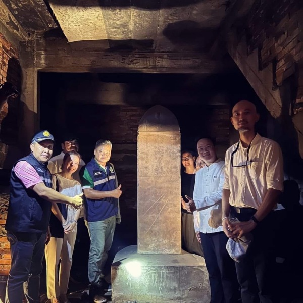
The rediscovery of the lost Inthakin pillar (2023).Translated from Thai (www.facebook.com/suraphondk), November 2023 Finally, let us end this essay on Thaphae Gate with the story of the long-lost Inthakin pillar; which was rediscovered on the 1st of November 2023. A city pillar can often be found in the exact geographical centre of a city. However, there are several exceptions to this rule, for example those cases where an old city pillar has been removed to a site in front of the town hall. Sometimes more than a single pillar can be found, for example Trat Province has two, and Lampang three. The Inthakin stone pillar, also known as the city navel pillar, was installed initially at the first replica of Thaphae Gate. In 1985, Chiang Mai constructed another, larger replica of Thaphae Gate and wall, which is the one you can see now. When the old replica gate, originally built in 1966, was disassembled, the Fine Arts Department of Chiang Mai took the pillar into its care, with the intention of returning it to its original location once the new Thaphae Gate was completed. On October 11, 1985, the pillar was brought to the Fine Arts Department.
The story starts with the revelation that the Inthakin pillar at Thaphae Gate had been missing for over four decades. Some claimed that it was stored at the Chiang Mai National Museum, but when inquiries were made, it was nowhere to be found. This created confusion and discomfort among those associated with the museum, turning a seemingly trivial matter into a source of unease for many people. Therefore, it is crucial to set the record straight. In 1985, the Governor of Chiang Mai initiated the construction of a new Thaphae Gate based on historical photographs. The Fine Arts Unit, together with the Provincial Public Works Department, oversaw the project. During the construction process, concerns arose that the Inthakhin pillar, originally installed at the Thaphae Gate, might be damaged. Consequently, the governor had it temporarily relocated to the Chiang Mai National Museum. The plan was to return it to Thaphae Gate once the construction was complete, following ancient traditions. However, there was no suitable place for the stone pillar installation, leading to the decision to place it inside the Thaphae Gate's wall, in a space with a locked door. Forty years passed, and a group of scholars began searching for the Inthakhin Stone Pillar to trace its whereabouts. They inquired with individuals unfamiliar with the matter who erroneously claimed it was at the National Museum. This caused distress for the museum's director. This situation persisted for an extended period, because most of the individuals involved in the affair had passed away.
At one point, someone claimed that photographic evidence existed confirming the presence of the Inthakin Stone Pillar at the Chiang Mai Museum. However, when I personally searched for it, it was nowhere to be found, dispelling any notion of its presence at the museum.
Subsequently, a group of educators and scholars came to seek information. I shared what I could recall and requested their assistance in coordinating with the municipality to obtain access to the locked room within the wall at Thaphae Gate. It was during this effort that the Inthakin Stone Pillar was rediscovered, actually standing there after being locked away for four decades. The rediscovery of the Inthakhin Pillar is important because those who knew of its whereabouts have all passed away. It is essential to clarify that the initial claim of the museum's possession of the pillar was not accurate, and this discovery sets the record straight.
|
|
More walled cities in northern Thailand.There used to be many more walled cities in northern Thailand, however, most of these fortifications have been demolished and the bricks reused for houses and road building. Many smaller villages in the Siamese Shan kingdom had just a ditch with a bamboo palisade. Some pieces of the old walls of Nan remain and have been restored, but they are only a very small part of the old wall. Here are a few more suggestions of historic towns, some not far from Chiang Mai:
Chiang Rai: White Temple and Black House.Between Chiang Mai and Chiang Rai there are notable differences. Chiang Mai is renowned for its rich history, temples, and cultural heritage. It boasts numerous historic temples, a moat-surrounded old city, and a vibrant night market scene. The city is also a hub for traditional crafts, cooking classes, and wellness retreats. Chiang Rai is a much smaller town, famous for its unique modern temples, such as the White Temple (Wat Rong Khun) and the Blue Temple (Wat Rong Suea Ten). The White Temple is a dazzling work of art, but not an historic temple. Chiang Rai's stone walls and gates were dismantled in the years around 1920 on the advice of Dr. Briggs, an American missionary physician, who argued that the area along the wall and the moat was muddy and filthy and therefore a permanent source of all kinds of illnesses, and that the wall also obstructed the flow of fresh air. 1
Thus, Chiang Rai's walls have vanished and are not traceable. A small section of the wall on the east side has been symbolically restored, but it is not similar to the original wall. The "White Temple" or Wat Rong Khun.
If you're traveling from Chiang Mai, please note that the temple is located at least three hours away by car. A brief day trip would require approximately six hours of travel time by bus and taxi. Although the White Temple is an impressive work of contemporary art, it may not justify a six-hour bus trip for a single day. To fully explore Chiang Rai, it is recommended to allocate at least one full day and two nights for your visit. Arriving early is advisable to avoid large crowds. While in the area, you can also visit the Blue Temple in town, although there aren't many other attractions. Therefore, it might be best to stay in Chiang Rai for one or two days. While you're there, don't miss Chalermchai Kositpipat's other artistic creation: the clock tower spectacle, which occurs hourly at 7, 8, and 9 p.m. And, of course, make sure to visit the "Black House." All in all, Chiang Rai offers a a lot of contemporary art experiences. A short history of Wat Rong Khun: remotelands.com There is an entrance ticket to the White Temple for foreigners of 100 Baht, but it is free for Thai nationals. The opening hours are from 8:00 am to 17:00 pm. The "Black House".
While the White Temple may be small in size, Baan Dam is a vast structure shaped like a Wat (temple), surrounded by approximately 40 smaller buildings and art installations. Interestingly, some local Thai people refer to the White Temple as heaven and the Black House as hell, emphasizing the stark difference between the two. The compound consists of various small and large buildings, serving as both art pieces and exhibition spaces. With so much to explore, one can expect to spend a lot of time here. The Baan Dam Museum is open daily from 9 am to 5 pm, with a brief closure for lunch from 12 pm to 1 pm. The entrance fee for adults is 80 baht.
links to literature.
Links on wikipedia and other sources.
Background: aboutme Any comments? Please mail me at : bytelife AT gmail.com
All photos copyright ©2024 R.Schierbeek. (except the historic black and white ones).
|
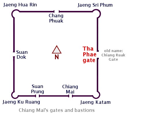 There are four corner bastions: Jaeng Sri Phum or Sripoom (NE), Jaeng Katam (SE), Jaeng Ku Ruang (SW) and Jaeng Hua Rin (NW). The term "Jaeng" is the Thai word for bastion or fort.


 Part of a historic map of Chiang Mai for Inthawichayanon, dated 1893.
Colouring and minor edits by me.
Part of a historic map of Chiang Mai for Inthawichayanon, dated 1893.
Colouring and minor edits by me.


 On the right is the outer Thapae gate with the offset (O) drawn in; which amounts to the width of a car lane. A car lane is generally between 2.5 to 3.25 meters wide (highways are wider); so for the offset we can estimate roughly 2,5 to 3 meters.


 The "White Temple," also known as Wat Rong Khun, is truly a sight to behold—a magnificent "Bling-bling temple" that is well worth a visit if you find yourself in Chiang Rai. This privately-owned art exhibit, designed in the style of a Buddhist temple, showcases the contemporary artistic vision of Chalermchai Kositpipat. The interior of the temple is relatively small, often leading to queues. While photography is prohibited inside, you can search for the artist online to catch a glimpse of the mesmerizing murals.
 The "Black House" in Chiang Rai, also known as the Baan Dam Museum, presents a stark contrast to the White Temple. Instead of the bling-bling of the White Temple, it displays a different kind of art; a rustic, earthy art. The museum features dark wood, brown earth tones, and an abundance of buffalo skulls.