|
Chiang Mai's national parks & motor loops | |||||||||||||||
|
Last update: Apr 2, 2024 A travel guide to the national parks around Chiang Mai.
Introduction.This is an overview of the national parks around Chiang Mai in Northern Thailand. The closest one, Doi Suthep park, is the prominent mountain to the west of Chiang Mai; with the famous Wat Phra That Doi Suthep visible as a gleaming dot halfway up the mountain. Doi is Thai for mountain, so Doi Suthep means Suthep mountain. Doi Suthep is very close to Chiang Mai; whereas Doi Inthanon, the highest mountain of Thailand, is at least two hours driving away (110km). There are a few more parks that are worth a visit, for example, not too far east are Mae Takhrai and Chae Son park. The high mountain range of Chae Son is just visible on clear days from a higher vantage point, like the higher floors of a hotel. Many people visit Doi Suthep or go down south to Doi Inthanon; but only very few head east to the quiet roads through the vast mountain ranges of Mae Takhrai and Chae Son park. That is the reason I have made descriptions of a few routes to the "eastern ranges." Most national parks have a visitor center with a Nature Trail, a walking or trekking route which usually starts at the headquarters. These visitor centers are often situated near prominent landmarks such as waterfalls, hot springs, or lakes. The condition of these nature trails can vary significantly, some are well maintained and signed, some are not maintained at all, and this makes embarking on a nature walk a bit of a gamble. The duration of these nature walks can range from an hour to a few hours, from easy to pretty steep and daunting. For example the Ob Luang trail is a loop of 1,2 km and takes about an hour; on the other hand, Khun Chae nature trail seems like a short walk of about 3 kilometers, but it is very steep, and quite challenging. This trail will take close to 2 hours to walk. Sometimes there is a map and information by a ranger at the visitor center, sometimes there is nothing and you have to find your own way. When there are signs these are usually in English and Thai. People have got lost in the past, and therefore in some parks the ranger will let you sign your name in a log book, so they have an idea who they are looking for when you don't return.
distance of national parks from Chiang Mai, and entry fees.
Loops through parks around Chiang Mai.The highways north and south are busy roads, but the mountain ranges to the east and west of Chiang Mai are great for motorbike cruising. For the Samoeng loop you will have to start with a stretch on the busy highway 107 northwards, or the highway 108 southwards.
All of these routes through national parks are free. The majority of the national parks' areas is absolutely free to drive though, they only charge an entry fee at the area around the visitors' center. The payable area is shown on the map. For free entry to the parks see : Free passage through the parks.
1] Doi Suthep park.Doi Suthep mountain is the focus of Doi Suthep National Park; the park area is more or less the full mountain. Doi Suthep is a relatively small mountain compared to the mountain ranges to the east of Chiang Mai.
Getting there is fairly straightforward: one can drive up to Wat Phra That Doi Suthep temple on Doi Suthep in about half an hour, either by scooter or by taking a songthaew (a public transport pick-up). For most tourists, this temple is the only glimpse they get of the national parks in Chiang Mai Province. To fully explore the temple, one would need approximately an hour, and another hour to visit the royal Bhubing Palace. Including the time it takes to travel from your hotel to the mountain, the entire excursion would take around four hours. Entry fee: Doi Suthep park only charges a fee for the visitors center/camping area. Hot tip: the temple is always busy, but on Sundays half of Chiang Mai goes on a trip to the closest attraction: to Doi Suthep mountain. As a result, the parking lot fills up quickly, and there tends to be a large crowd around the temple.
The Samoeng Loop - twisties for the Easy Rider.Samoeng loop, 100km. Duration: 3 hours, including a stop. The Samoeng loop in Thailand is a breathtaking 100-kilometer ride on winding mountain roads around Doi Suthep mountain. It is renowned for its "Perfect Curves," which are well-banked, smooth, and offer stunning views of the surrounding nature. Unlike the busy road to Pai, there is little traffic to worry about. The loop winds around and through Doi Suthep�Pui National Park and takes you past a famous botanical garden, royal projects, and a few elephant parks. The road's excellent condition and lack of traffic make it an ideal Easy Rider route. All you have to do is lean your bike into the curve, open up the throttle and enjoy the ride.
Why not start your Samoeng sojourn not too early in the morning and head north on the busy highway 107. The highway up north is busy, and often has traffic jams. At Mae Rim, about 15 kilometers north of Chiang Mai, turn left onto road 1096, which will take you through the lush green countryside and towards the hills. There is a large "Samoeng" sign over the highway. Mae Rim is a village on the highway 107, and has a few posh hotels and resorts. The Dara Pirom Palace Museum in Mae Rim is worth visiting, the museum is a historic wooden mansion which was home to the famous Lanna princess Dara Rasmi (or Rasami), who was one of the consorts of Chulalongkorn, King Rama V of Siam. Entry fee is 20 baht. A few kilometer down the 1096 road there used to be a tourist village called Baan Tong Luang. This village had no less than 7 hill tribes: Akha, Karen, Lahu, Lisu, Padaung, Hmong and Kayaw tribal people. Obviously, these hill tribes never live together, so it is a bit of a tourist trap. These hill tribes do not live near a large modern town like Chiang Mai; their villages and original way of life in the hills and mountains have mostly vanished. One of the tribes is the Padaung or Longneck women tribe; these Longneck women are refugees who originally lived in a remote area in Burma near Loikaw. However, the village has been closed since the pandemic outbreak. There are two non-profit royal projects on the Samoeng loop, both founded by King Bhumibol, with the aim of helping hill tribes achieve a better life, preventing deforestation, and promoting alternative agriculture. One of these projects, located on the side of Doi Mon Cham mountain (also known as Mon Jam), has become a popular tourist attraction. Mon Cham was once a forest which transformed into a charming eco-agro-tourism destination. It is a collection of camping sites, strawberry farms, coffee plantations and lookout points on the side of a mountain. One can enjoy activities like kart riding and ziplining, and there is a large glamping area on the mountain, which is popular with Thai tourists.
As you enter the Mae Sa valley towards the small town of Samoeng, the road begins to twist and turn. There are a few elephant parks; once past these the road gets much quieter as it continues west towards Samoeng; you can drive through the beautiful valleys and mountains on a scenic twisty road dotted with villages, temples and forest. A bit further on is the Queen Sirikit Botanical Garden (QSBG) which is a famous mountainside arboretum and garden. This is the largest and best botanic garden in Thailand, set against a mountainside in a large forest. More here: QSBG Garden. Soon you go up into the mountain, and this northern side of the mountain is always cold. You did put on enough warm clothing for the ride? After the Samoeng Forest viewpoint the road leads downhill, until you reach a T-crossing. At this junction, you have the option to turn right and drive 10-minutes through the strawberry fields of the Samoeng valley. After a few more hairpins turns, you arrive at the small village of Samoeng. Although the village has just one coffee shop, there are a few restaurants. For a well-deserved lunch break, I recommend visiting Supanee's eatery. Supanee's restaurant serves authentic Thai cuisine at modest prices.
From Samoeng, return to the T-crossing; keep on going straight on road 1269, which will take you along the ridge of the mountains and offer great views of the valley below. There are a few amazing downhill stretches here which are even better than the first half of the loop. As you continue on this road, you'll pass through several small villages, each with its own unique charm.
And if you keep your eyes on the left side, after the long downhill stretch there is some kind of bungalow park, with a lot of very small artistic holiday cottages, which is worth a visit. It is called Phu Jaya Clay House, and seems to cater mostly to Thai tourists. There are no signs, so it is easy to miss. The room rate for the very small cottages is well over 200 euros, and perhaps that is why there seem to be few visitors here. Worth a look around anyway. Next to Phu Jaya Clay House is the very nice Royal Rose Garden, a large rose plantation with a restaurant. It has a large Thai food menu with limited western options, but has good drink selection including coffee and also some delicious cakes. The official entrance to the rose garden is just a bit further down the main road, the exit is signed in english and thai. Entry is free. There are more resorts and coffee shops on the way back, like the Belle Villa Resort Chiangmai, and the large The Doi Resort and Restaurant, which is right on the roadside and has good cappuccino, nice cakes, and a wonderful view. The full "Samoeng loop" around Doi Suthep is about 100 kilometers and takes about 3 hours on a motorcycle or scooter. The roads are in good order, the traffic is light and thus it is an easy trip.
Samoeng loop: 100km
| |||||||||||||||||||||||||||||||||||||||||||||||||||||||||||||||||||||||||||||||||||||||||||||||||||||||||||||||||||||||||||||||||||||
|
2] Mae Takhrai park.Unexplored Hot Springs and Cool MountainsDoi Suthep is either busy or crowded, but there is an unexplored area to the eastern side Chiang Mai: Mae Takhrai and Chae Son park. Mae Takhrai park is known for its picturesque rice fields and hot springs. Visitors can trek through the park's forest, or bathe in the natural hot springs. And because these parks are large and very few tourists travel there; one can enjoy plenty of birds and butterflies instead of busy roads. Mae Takhrai park is surrounded by mountains with an altitude of 400 to 2031 meters; this national park includes rain forests and mountains of limestone. There are hot springs, small lakes and reservoirs surrounded by densely forested hillsides. By the way, the Thai word "Takhrai" means Lemon grass. Mae Takhrai is the largest park around Chiang Mai, with 1114 square kilometers, although it is not clearly indicated on existing maps of the Thai national parks. It has three separate entrances; the headquarters is right on highway number 118 to Chiang Rai, and there is also a visitors' center and nature trail at the village of Mae Takhrai further south. Entry is free.
Mae Takhrai Park is also home to "Flight of the Gibbon"; a zip lining experience in the beautiful mountain rainforest around Mae Kampong. The mountain jungle of Mae Takhrai has much larger trees than the small Doi Suthep Park which is not suitable for zipline adventures. Jungle Flight is another Eco-adventure company near Thep Sadet that does abseiling, nature walking and zip-lining in Mae Takhrai Park. Mae Takhrai has been an unregistered national park for many years; it has been approved and gazetted (registered) in 2016. It does not appear yet on Google Maps.
The Mae Takhrai loop.Mae Takhrai loop, 110km. Duration: 3 hours. To see the less visited parks and pristine nature of Chiang Mai province, head east towards Mae Takhrai and Chae Son national park. In less than an hour's drive (about 35 kilometer) on highway 118 you can be in Mae Takhrai national park. The Mae Takhrai loop (see map below) follows the half circle of the Mae Tha fault line; the fault is visible as a valley around Chiang Mai. Starting from Chiang Mai it is about 110 kilometers.
A clockwise route from Chiang Mai could be: Drive northeast on the 118 highway, go past Doi Saket, and 30 kilometers from Chiang Mai you will reach Ban Pong village. The navigation is a bit tricky, because there are 2 exits close together. There are 2 exits for Ban Pong, the first is for Ban Pong Kum; the second is for Ban Pong Din. Take the second exit for Ban Pong Din; just past a walkway overpass bridge. One needs to go to the center line of highway 118, cross the busy road, and turn sharp right into the road to Ban Pong Din. Once in the village of Ban Pong Din, you may come across a surprising teak house in the shape of a Japanese temple. Take the first small road right to find it. This mansion is private, but so large that one may catch a glimpse of it from the roadside. Someone has spent a fortune on hardwood beams to build this fantastic replica. If you can't find the "Japanese temple", look for the Don Yen arboretum, a medium sized arboretum. This arboretum is open to the public, and part of a low-key private bungalow resort.
Once out of Ban Pong Din and past the hot springs, continue south on road number 3005, which must be one of the most scenic twisty roads around Chiang Mai. Ricefields and villages, and quick sharp turns on a winding little road, what more do you want on a motorbike? At the village of Huai Kaeo pass through the village, and about 500 meter further make a left turn into road number 1230. There are no signs for Mae Takhrai park, but one of the many signs says "Ban Khun Tha". Khun Tha is a village further down the 1230, probably near the Khun Tan railway tunnel. This road number 1230 to the viewpoint used to be a small dirt track, and has only in 2017 been newly constructed and asphalted. Follow the road past small villages and pretty soon you will get to the entrace of the park. Slowly wind your way up the hills to the viewpoint. Continue on the twisty but very quiet and easy road through Mae Takhrai Park, and after a while you'll spot a large pink temple: Wat Mae Ta Khrai. Wat Mae Tha Krai is a temple complex situated near the Mae Ta Khrai National Park visitor center. On the right side of the road is the temple, with two huge statues of the revered monk Khuba Siwichai; on the left side is the road to the visitor center. Wat Mae Tha Krai has a rather outragous "Zombie display", with statues depicting the Buddhist hell. A most entertaining temple to make a short visit and have a look at the many, many ways in which one could be tortured in the afterlife. Only if one has collected bad karma, don't worry. On a side note, hell is not part of the original Buddhist teaching. The early Buddhist sutras stressed that there was no god or other supernatural intelligence passing judgments or giving guidance. Buddhism asserts that life does include suffering, but there is no place or afterlife like the Christian hell. There is however the concept of karma, and reincarnation. Karma means action, cause and consequence. If one accumulates too much bad karma, one might reincarnate as as dog. So be kind to your snappy pooch, he may have been a human who misstepped in his last life. Now all he can do is bark and be grumpy. At the next crossing turn right onto road number 1229 which brings you to Mae On and to the nicely winding fast highway number 1006 through small villages back to Chiang Mai. San Kamphaeng is a nice place for a lunch or coffee stop. On the 1006 road, before and after San Kamphaeng there are 2 museums, more info here: museum.
There is a Nature Trail near the visitors center on road number 1230, which starts around the lake and follows the stream. This visitor center is easy to miss, though there is a large sign on road 1230. If you go past Wat Mae Tha Krai and admire the pink temple, you have just missed it. The Mae Takhrai reservoir is surrounded by mixed deciduous forest and bamboo forest. There is a 3 kilometres trekking route around the reservoir. Two camping spots are available around the lake.
| |||||||||||||||||||||||||||||||||||||||||||||||||||||||||||||||||||||||||||||||||||||||||||||||||||||||||||||||||||||||||||||||||||||
|
3] Chae Son (Jae Sorn) park.Chae Son is pronounced as "Jae Sorn" by Thai people, and they don't understand "Chae Son". This is one of the most highest forest parks in Northern Thailand; and with an area of 592 square kilometers much larger than Doi Suthep park. The mountain range that runs north-south through Chae Son forms the border between the provinces of Lampang and Chiang Mai. Doi Langka is the highest mountain of the range at 2031 meters. The high mountains and cool temperatures make Chae Son Park very suitable for growing coffee and tea, and small coffee, tea and banana plantations are dotted along the road.
The Chae Son loop is not on the tourist radar at all. Driving along the twisty, quiet mountain road, amidst beautiful scenery, you'll rarely see other cars - perhaps an occasional meeting with a villager on a small motorbike. Small, remote mountain villages are nestled in grand forest valleys. How to get there: Below is a map of Chae Son park and the headquarter and visitor area on the eastern side. The headquarters/visitors center of Chae Son NP at the village of Chae Son is easily reachable from Lampang; from Chiang Mai however, it is a more than 2 hour trip up the highway 118 and then the mountain road number 1252 right through the national park. The Chae Son park visitor center has an entry fee of 200 Baht for foreigners. More: www.thainationalparks.com wa
The Chae Son loop.
Chae Son loop, 180km. Duration: 5 hours, including a stop. Drive northeast on highway 118 for about 50 km towards Chiang Rai. Here the highway 118 has a very large sign over the road pointing to Chae Hom. Turn sharp right into the 1252 road. This mountain road winds through forests and ridges at an altitude of 600 - 1400 metres; which means guaranteed cool temperatures. Off the busy, monotonous highway number 118, the scenery changes abruptly. Tall trees line the sharp turns of the narrow mountain road. As soon as you enter the forest the road starts to climb steeply, and the air cools down quickly.
You are now entering the high ground where coffee and tea is grown. The cool climate in Chae Son is suitable for growing coffee and tea, as well as small banana plantations tended by local villagers living in the mountains. These plantations are maintained by the people of small villages, sometimes just hamlets of a few simple houses with corrugated iron roofs.
Driving southeast along the number 1252 road, it will take at least 1,5 hours to get to the Chae Son Visitors center. Close to Chae Son town, turn off the 1252 into the Chae Son park visitor center (see map), which is clearly indicated. There is an entry fee of 200 Baht for foreigners at the visitors center and immediate surrounding area of Chae Son park. The visitors center is a large area where hot springs flow into a number of ponds on a grass field covered with rocks. There are some eateries which provide drinks and snacks; and the eggs which one can cook in the very hot water. While the hot water that emerges from the springs can be around 70-80 �C, visitors can take a dip or relax in some of the smaller pools at lower temperatures. There are also cabins next to the springs for private bathing.
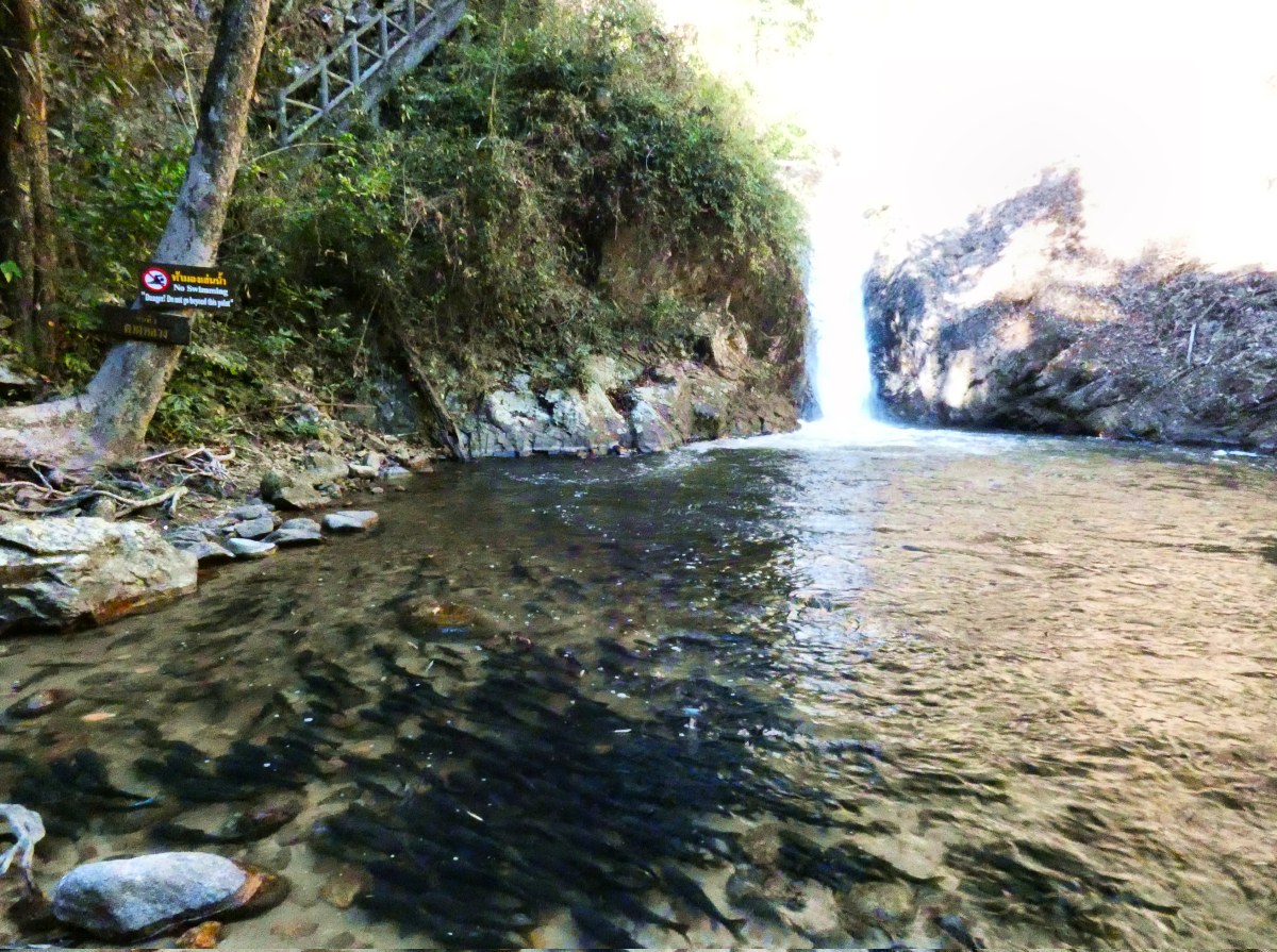
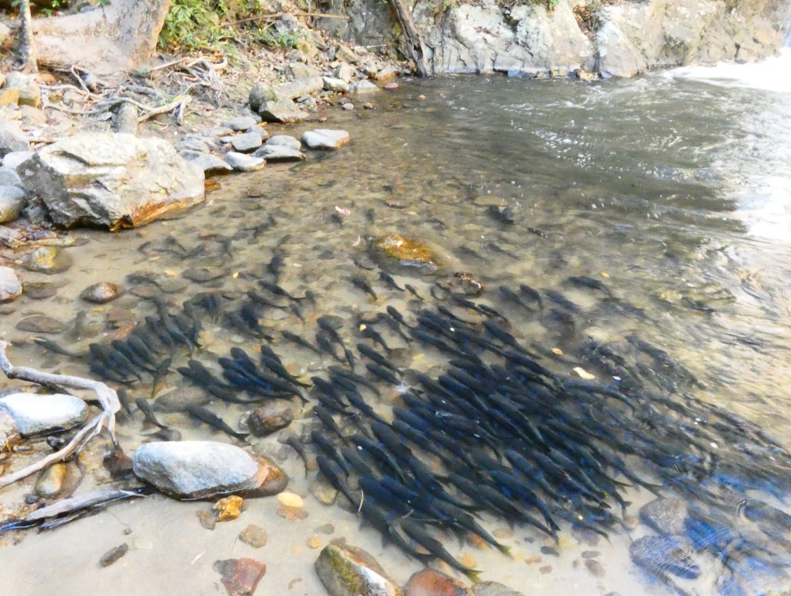
There is also a short hiking trail leading to the 6-level Chae Son waterfall, which is located 1 km upstream in a narrow gorge a short walk away. Have a look at the creek ponds on the way to the waterfall, they are filled with large shoals of fish; which need to swim upsteam day and night, for eternity. The Cha Son Waterfall is higher than the Mae Kampong waterfall.
There are eateries, snack stands, and picknick opportunities at the visitors area. Note that the southern part of the Chae Son loop is a small concrete road with some very steep sections. One needs to apply full braking for some long stretches. This part is not suitable for a scooter.
Mae Kampong eco-village.After one of these steep stretches one passes through the charming village of Mae Kampong. It is a small village of just over 130 houses, which has become a model for ecotourism and community tourism in Thailand. At an altitude of 1300 meters, Mae Kampong is ideal for growing tea, and coffee cultivation. Mae Kampong is an eco-village where people come to stay a few nights in the homes of local families to experience village life. A group of village leaders started to make Mae Kampong a tourist attraction in the form of ecotourism a few years ago; this has transformed the village into a popular tourism hotspot. Nowadays, some of the houses are actually quite new, not repurposed old buildings. The village has a certain charm, but the quaint houses are often new buildings and sit beside the authentic old ones. There are local cafes and restaurants on the small road through the village. There is also a small waterfall, various rapids and it is possible to go round the back of the main street homes and shops and follow the stream downhill past little temple shrines. Because it is a very popular getaway on weekends, it's better to go there on weekdays, or perhaps try a homestay. Is it worth travelling slightly more than an hour from Chiang Mai to this tiny mountain village? There are many mountain villages in Chae Son and Mae Takhrai park which are more authentic and are not tourist-hotspots. However, these usually do not have cafes and restaurants, and few or no english speaking villagers.
For a one-time visit, it might be best to rent a car or scooter and do the Takhrai loop, and visit San Kamphaeng, a hot spring, and a museums. Be aware that the village is located in a mountain valley on a steep slope. One needs a powerful scooter with good brakes.
| |||||||||||||||||||||||||||||||||||||||||||||||||||||||||||||||||||||||||||||||||||||||||||||||||||||||||||||||||||||||||||||||||||||
|
More remote loops and parks.
All the Mae Hong Son loop options.The Mae Hong Son loop is a twisty road through the mountains of Northern Thailand. It is famous in motorcycle circles, but there are also people who do the loop by car, and many backpackers take the frequent minivans from Chiang Mai and rent a bicycle or scooter in Pai. Since Pai is a small village there are no taxis, just a few motortaxis. The legendary Mae Hong Son loop starts from Chiang Mai on a very twisty road to Pai, then a scenic route to Mae Hong Son, down to Mae Sariang and back to Chiang Mai. This 600-kilometer journey can be comfortably completed in 5 to 6 days, although a minimum of 4 days is recommended. Pai, a busy backpacker town with a very nice night market is the first stop. The route offers stunning karst landscapes on the way to Mae Hong Son, a tranquil mountain town that sees relatively few tourists, preserving its authentic tribal influence. If one takes the "Short loop", there are nice landscapes and a stop in the village of Mae Chaem which is a center of textile handweaving. To return to Chiang Mai, the road traverses Doi Inthanon mountain. The next three itineraries are some options and shortcuts: one can do the full loop, or a shorter and perhaps better version.
Best of the loop: Up and Down to Mae Hong Son.Start off driving north on the 107 highway, and turn left on the well signposted 1095 road to Pai. After a night in Pai, drive 110 kilometers to Mae Hong Son over a high mountain pass. Stay in MHS, next day back to Pai to visit another night market there, and return to Chiang Mai. An alternative route with less traffic is the 3009 shortcut. After you have passed the turnoff to Samoeng (the 1096), just 1km past Mae Rim, turn left at the traffic light. You can now follow the rural 3009 road, until it joins with the main 1095 road to Pai. Same distance, easy to follow, curvy but no sharp turns and much nicer than a busy highway. Distances: 130 km: Chiang Mai - Pai 110 km: Pai - Mae Hong Son 480 km total (return)Alternative route: the 3009 shortcut from Mae Rim. Duration: 3 nights, 4 days. On the way from Pai to MHS you pass through Soppong, a small village that is close to a few famous caves, like Tham Lot cave. Soppong is also called Pang Mapha, which is the old name of the village, situated along the bank of the Yang River. If you stay in Mae Hong Son town, the Doi San Fah viewpoint is just half an hour away. It is a small and steep road up, and maybe one of the twistiest roads in the north. Warning: do not try this with a scooter. The last part up the mountain is twisty and very steep, and once up there a U-turn is impossible, so you are committed to drive all the way up to the viewpoint. There is a 200 baht entry ticket for the Namtok Mae Surin National Park, but if you ask nicely, you may be able to pass and visit the viewpoint. After all, 200 baht for a very short visit is a bit steep, isn't it? If you want to walk the Mae Sakut Nature Trail, you have to pay up. The Mae Sakut Nature Trail is 7,5 km; a walk of about 3 hours. The famous Mae Surin waterfall is at the other side of the national park, way down near Khun Yuam. This high waterfall may be worth the entry ticket.
This road is so twisty because it is an old elephant trail, and it was the first direct road from Chiang Mai to Mae Hong Son. Because it was too steep for cars, the Japanese created a new road through Pai to Mae Hong Son during World War 2. The current road nr. 1095 to Pai follows the Japanese road.
The Short LoopAfter a visit to Pai, make your way to Mae Hong Son. From Mae Hong Son continue south on highway 108. At Khun Yuam take road 1263 east to Mae Chaem, a small village with only a few guesthouses. The next day, cross over the mountain pass of Doi Inthanon. If you don't intend to visit Doi Inthanon, you can tell the people at the checkpoint, and they will let you through without paying the entry fee to the national park. From Doi Inthanon it is a straight drive up highway 108 back to Chiang Mai. This is a busy and boring straight highway, with some traffic jams in the villages as you get close to Chiang Mai, so a slightly longer route along the "canal road" nr. 3035 is a lot better and faster. Follow the 108 for about 22 km, and turn left at the sign "Mae Wang" to take the 3035. From there it is about 40km along the "canal road" to get to Chiang Mai. Distances: 130 km: Chiang Mai - Pai 110 km: Pai - Mae Hong Son 165 km: MHS - Mae Chaem 130 km: Mae Chaem - Chiang Mai 535 km totalAlternative route: very twisty mountain road 4009 through Mae Surin National Park; about 1 hour extra. Duration: 3 nights, 4 days.
The Full MHS Loop
The full 4-day Mae Hong Son Loop has three stops in Pai, Mae Hong Son, Mae Sariang and then back to Chiang Mai. Here's a detailed route description with distances and road numbers of the 4 sections:
An alternative route with less traffic is to drive up to Mae Chaem, and from there turn east and take the route across Inthanon park. This is 50km longer, so it's up to you if you want to see Doi Inthanon, or take the shorter, regular route which passes by Ob Luang National Park, which is also a pleasant park to visit, take a break and perhaps do the 1 hour nature trail. Distances: 130 km: Chiang Mai - Pai 110 km: Pai - Mae Hong Son 165 km: MHS - Mae Sariang 195 km: Mae Sariang - Chiang Mai 600 km totalAlternative route (green): 50km longer. Duration: 3 nights, 4 days.
The Journey Begins: 762 curves to Pai.In Thailand, traffic flows on the left-hand side of the road, just like in the UK, but a lot faster and less disciplined. Here, the law of the road is might makes right, and the larger your vehicle, the better. While speed limits exist, speed enforcement is a rarity, allowing you to go as fast as you like. Many young backpackers travel by scooter on their first trip to Pai; which may not be the best choice for a novice rider. The twisty mountain road to Pai is a 130 km long drive; and famous for its 762 turns. It's an intimidating mountain road, even for experienced motorcyclists, let alone beginners. There are few viewpoints and there is a lot of traffic; for example, the many minibuses travelling to Pai which usually drive at high speed. In short: it is not safe and not for beginners!
Bear in mind that the road to Pai has garnered notoriety for all the wrong reasons. It's infamous for its sharp bends, potholes, and is classified as one of Thailand's most treacherous roads. A few years ago, in 2016, the road was widened in some places so you can now easily overtake that slow driver; who is trying to go uphill on an underpowered scooter with his girlfriend on the back. However, most of the curves on this road still lack proper road banking or superelevation. Negotiating these bends requires foresight, precision and experience. Unfortunately for some bikeriders, experience is what you get - just after you need it.
Where to stay in Pai (Map)Pai, once a quaint mountain village, underwent a dramatic change when it became a popular destination for backpackers. It morphed into a cool hippie oasis with a great atmosphere and lively night bazaar. Nowadays, Pai attracts not only young hippies but also a diverse mix of older visitors. The backpackers who come to Pai are known for their amiable nature, and unlike other places, they refrain from hosting all-night raves due to the chilly weather. In one word, Pai is cool.
Within downtown Pai, the rectangle on the map, there may be some noise due to a few nightclubs that operate until midnight. Bar street has especially noisy bars. For those seeking tranquility, staying in a bungalow located outside the central area of Pai can be an excellent option. In Pai town itself, there is a wide range of budget accommodations ranging from 500 to 1000 baht. Additionally, there are numerous mid-range hotels and some expensive resorts, primarily located near the Pai River, and a few to the west of town. During the low season, finding accommodation is generally hassle-free, but around Christmas and New Year it can become more challenging. Pai offers a variety of bungalow parks in all directions; here are a few options within a 10-minute walk: 1] Cross the bamboo bridge to the vast Bungalow plain, which is a short walk away. This area offers many small bungalows and bamboo huts in a quiet setting. While the bamboo huts may have limited comforts, there are many bungalows that provide private bathrooms. Walk a few minutes further and there are also luxury bungalows with their own balconies - the range of options is large. 2] Walking east for 10 minutes there are also some bungalow resorts, for example Pairadise Resort on the road to Wiang Nuea. 3] If you walk approximately 10 minutes west towards the Chinese village, you'll find more bungalow resorts. For example Oasis Pai Resort has bungalows. The Quarter is a resort with bungalow type accommodation, arranged in blocks with two upper and two lower rooms in each unit. One can also rent a scooter or bike and head north on the road to Mae Hong Son. Up there are some very nice isolated resorts, but it will take about half an hour on a bicycle to reach them. Going south, you can walk for 10 minutes and find a few more bungalow resorts. A last hot tip: In daytime the temperature can be about 30 degree Celcius, but Pai is a mountain village with a mountain climate. During the high season(december and january) the temperate will drop quickly to 15 degree C. Around this time of the year an aircon is not needed.
Hot springs in Pai.)There are two natural hot springs near Pai: Sai Nagm and Tha Pai hot springs.
Down south, close to Huai Nam Dang park, there are also a few resorts with mineral water. For example, Pai Hotsprings Spa Resort has a circular hot bath in the resort garden for just 100 baht. Mueang Rae Pai Geyser Hot Springs is located about 20 kilometers south of Pai, a scenic 40-minute ride south on Route 1095; turning off at the sign Ban Wat Chan and following route 1265. This hot spring is just a pond next to road 1265, and not very scenic. Entry is free. To be continued ..........
The South: Doi Inthanon.Doi Suthep and Doi Inthanon are by far the most popular day-tours - most tourists have it on their To-do list. Why? Because Doi Suthep is a prominent mountain right next to Chiang Mai town; and because Doi Inthanon is the highest mountain of Thailand. And both have convenient roads to the top. If you want to avoid the crowds then try to avoid these trips up the mountain on weekends; especially on Sundays. Highest car park in Thailand. (review quote) Inthanon is nice because you see three things at once: the highest mountain in Thailand, nature trails and some waterfalls. And a lot of highways, for the most part. Before you get to the winding mountain road, there will be a lot of straight busy highways; and then a busy parking place at the top - you are not the only one who want to visit Doi Inthanon. After following a queue of fume belching traffic for about an hour you'll arrive at the top of Doi Inthanon to fight for a parking space; then be puzzled as to why you made all that effort to get here. No view to speak of, just an unkempt car park with a bit of grass and trees at the end and a huge military satellite concrete building to one side. Nearby, there are 2 small nature trails you can walk on, but as they are packed with Thai holiday makers chatting at full volume, any wildlife you may have had the chance to see is long gone. Temple half way down offers good views and is ok but really, there are hundreds of places in Thailand worth the time, effort, and expense to visit. Sadly this isn't one of them. Doi Suthep is far more rewarding. How to get there: The top of Doi Inthanon is about 110 kilometers away; which will take about two hours driving, one way. It is a long drive on mostly busy highways until you get close to Doi Inthanon. Doi Inthanon entry fee: adult: 300 baht, children: 100 baht. Kew Mae Pan hiking trail per group: 200 baht, Royal pagodas costs another 40 baht. Booking a trip to Doi Inthanon is always possible the day before - check the weather and visibility first. If you can hardly see Doi Suthep from the old town, you won't see much on the top of Doi Inthanon.
The North: Si Lanna, elephants and Bua Tong waterfall.Si Lanna or Sri Lanna National Park is not very spectacular, most visitors go for boat trips on Mae Ngat lake (Mae Ngad reservoir), which is the main attraction. The headquarters is next to Mae Ngat dam, but you can ignore it and go straight to the lake. Overnighting on a houseboat is about 500 to 1000 Baht. One can do a forest walk along the lakeside of about 2 kilometer; the entrance fee is 100 Baht for foreigners.
In the same direction as the Mae Ngat dam, and not too far from it, is the Bua Tong waterfall, the "sticky waterfall" made of calcium, which is quite popular. And on the way to the Sticky Waterfall is Wat Ban Den. It is a relatively unknown temple, just east of Mae Taeng in the small Inthakin village. Yes, its is relatively unknown by westerners, but the Chinese tourists, who have discovered Chiang Mai a few years ago, certainly know about it. It is not signposted in English so you'll need a GPS map to find it. Wat Ban Den is one of Chiang Mai�s most remarkable and surprising temples; and one of the largest temple complexes in Chiang Mai province. The complex contains a large number of structures including an ordination hall, a viharn, a chedi (stupa), etcetera. All buildings seem to be double the size of normal temple buildings, which gives it a strange effect. A few large mythical Naga serpents guard the Wat on each side of the stairs, and all over the temple grounds are white Singha lion figures. As you probably guessed from the Naga serpent photo below; the Wat Ban Den temple is relatively new. It was completely renovated in 1988 by the abbot Kruba Tuaengg, who aimed to establish a Buddhist wat with spectacular effects, so one has to be prepared for a bit of special "Disney effects". Wat Ban Den is open 8am � 5pm everyday. No admission fee.
And if you are interested in elephants: just beyond Mae Taeng village is the "Mae Taeng river valley", and here are a few elephant parks located almost next to each other. Take the wide road 5 kilometer past Mae Taeng village which veers off to the left. The first elephant parks are on the wide main road; but after driving a while the road becomes narrow, the forest deeper, and you may ask yourself: where is this twisty road going? Is it worth going any further?
Then suddenly, the scenery opens up into a broad valley, surrounded by mountains through which the Mae Taeng river slowly meanders in a large, lazy curve. On the grassy plain some animals are grazing. What are the little dots in the landscape? In this charming valley the Elephant Nature Park is located, the largest ethical park in Thailand. Elephant Nature Park (ENP) is closed to casual passers-by, so one can only look from outside the park. Some of the other parks can be visited, like Mae Taman (Maetaman) Elephant Camp, Thai Elephant Home, and Mae Taeng (Maetaeng) Elephant Park.
How to get there: highway 107 is the obvious choice to go to ENP or Mae Ngat lake, but it is a very boring, straight, fast and busy highway. For ENP, go up the 107 highway, go past Mae Taeng village, and 5 kilometer further take the wide road which veers off to the left.
Why go there: Driving more than 2 hours just to see a waterfall is a long trip, but visiting a few more places while you're up there makes it worthwhile. A plus point: it's a long boring highway drive, but the Bua Thong waterfall entry is free. Some of the elephant parks are also free, but ENP is not. Have fun!
Chiang Dao mountain and wildlife sanctuary.Up north and a bit closer than Doi Inthanon is the strangely shaped Doi Chiang Dao (Chiang Dao mountain), the 3rd highest mountain in Thailand and famous with birders and trekkers. Chiang Dao is not a national park, but a wildlife sanctuary. For some reason it is not on the tourist radar and largely undiscovered. If you'd like to see a beautiful, stunning mountain, then drive to Chiang Dao and visit the large cave system. Only 5 minutes driving further, around the corner of the cave, is the picturesque Wat Tham Pha Plong, a tranquil little temple at the top of 510 steps at the side of the mountain. The mountain setting of this temple is more picturesque than the one on Doit Suthep, and there are very few tourists. In 2021 UNESCO declared Chiang Dao Wildlife sanctuary the Doi Chiang Dao Biosphere Reserve.
Chiang Dao Wildlife sanctuary and Chiang Dao mountain has foreigner fee of 200 baht. Just like Doi Inthanon, the entry fee is only payable when you go up the mountain, not at Chiang Dao cave, the hill temple and the beautiful scenery at the base of the mountain.
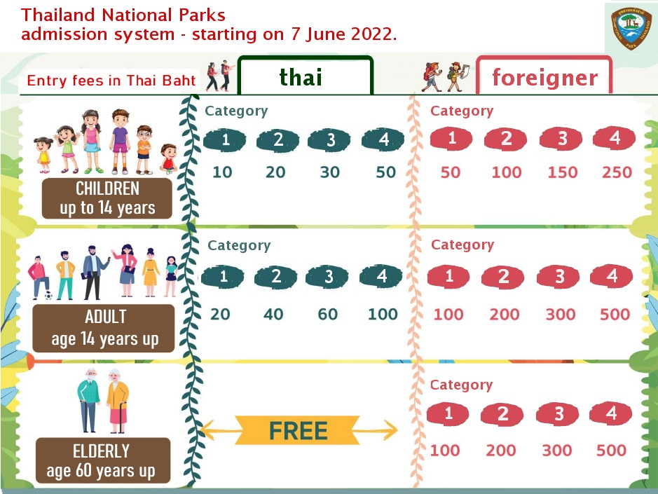
Free passage through the parks.Most of the national parks are free to drive though, though they sometimes charge an entry fee between 100 to 300 Thai baht at the area around the visitor center. To circumvent these fees, visit the park, but not the visitors' center. In the majority of parks, between 95% and 100% of the area is accessible without charge. The exception is Doi Inthanon, which has a checkpoint at the foot of the mountain. If you are on the Mae Hong Son loop, and only want to a quick drive through Doi Inthanon park from Chiang Mai to Mae Chaem, they will wave you through. Chae Son national park charges an entry fee at the area around the visitors center; which is 200 Baht for foreigners. This visitor area is a very small area of the park, where the hot springs are. There is also a hiking trail to the Chae Son Waterfall; a 6-level waterfall. There are eateries, snack stands, and picknick opportunities. Once again, it's worth emphasizing that all of these routes through national parks are free; with the exception of Doi Inthanon. If you want visit the top of Doi Inthanon mountain, you will have to pas the admission fee of 300 baht.
Dual pricing in Thailand.Dual pricing systems are usually intended to charge foreign tourists more than locals. Thailand is not the only asian country using dual pricing. For instance, Indian nationals can enter the Taj Mahal for 40 Rupees, whereas foreigners have to pay a slightly higher fee of 1000 Rupees. In Thailand many museums and all national parks use a dual-pricing policy; with foreigners have to pay 5 or 10 times as much as locals to enter a park. The Thai entry fees are shown in Thai script, and thus not obvious to the western tourist. The visitors center of a park is usually a nature trail, a hot spring or a waterfall. To avoid the high foreigner entry fee and get a genuine experience of the national park, consider bypassing the visitors center. But what exactly are you paying these entry fees for? Is it a splendid stroll along a nature trail? While Doi Inthanon has some good nature trails, other, less well-known parks often have inconsistent or even absent signage, with trail maintenance being entirely neglected. As a result, one may get lost or confused. It's a good idea to bring an offline GPS map with you or turn back if you feel disoriented to avoid getting completely lost.
The entry fee system is rather complicated, as shown above. A potential improvement to the dual pricing system in Thailand could involve the introduction of Unified Pricing. Implement a single, unified entry fee for all visitors, regardless of their nationality. This would eliminate any perception of discrimination, and certainly lower entry fees would greatly enhance the number of foreign tourist visiting the National Parks. Thereby the net result could be the promotion of National Parks and tourism, at the same cost.
National park links on Wikipedia.Entry fees are only charged for the visitors center and camping area of the park. Mae Takhrai, Ob Khan, Khun Chae and Si Lanna park are all free.
Youtube videos
| |||||||||||||||||||||||||||||||||||||||||||||||||||||||||||||||||||||||||||||||||||||||||||||||||||||||||||||||||||||||||||||||||||||
|
Background: aboutme Any comments? Please mail me at : bytelife AT gmail.com "Travel is not a vacation, it's an experience.".
All photo's copyright © 2022 R.Schierbeek.
| |||||||||||||||||||||||||||||||||||||||||||||||||||||||||||||||||||||||||||||||||||||||||||||||||||||||||||||||||||||||||||||||||||||