|
|
Last update: Nov 15, 2023
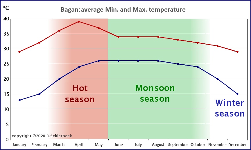
The climate in Myanmar.The Southwest monsoon over India and Southeast Asia is among the most impressive weather systems on earth. The summer monsoon brings 80% of the subcontinents' rainfall and its arrival is of critical importance to over a billion people. India and Myanmar are similarly affected by the monsoon rains; and both countries receive huge amounts of rain. Myanmar has a typical tropical monsoon climate with three seasons: the hot period, the monsoon and the cool and dry winter. The hot season starts somewhere in March and lasts till May, the rainy season starts around the end of May and ends in October, and the cool, dry season stretches from November to March. The monsoon weather you will encounter depends very much on where you are going, because Myanmar has some of the wettest areas on earth but also some much drier zones. The coastal zones and beaches bear the brunt of the monsoon rains, for reasons explained below. Your weather can be an occasional monsoon shower, but also flooding and torrential rain. A bit of rain in a tropical climate is not so bad, it brings some well needed cool wind and fresh air along!
When is the best time to visit Myanmar?Winter - November to February.The winter is the best time to visit; this is the busy high season for tourism. The weather is warm but not stifling, and some cool nights are possible but most of the time you will probably use air conditioning. In November there is little rain but beautiful cloudy skies and fresh sparkling greenery everywhere. December and January are slightly cooler. Sometimes a cold spell might occur in January when one needs a light jacket and sweater. The hot season - March until MayFrom sometime in March, it will slowly but surely get quite hot; the daytime temperature can be around 35 degree Celsius, but also soar up to about 40 degrees. This is the time of sweaty nights, which are unbearable without air-conditioning, and days when you have to avoid the sun in the afternoon and drink lots of water. The few Mango rains will not bring much relief. The Monsoon - May until OctoberThe monsoon season usually enters southern Burma around May 15, and arrives in Yangon around May 20. With the arrival of the first rains, and the pleasant monsoon breeze, temperatures drop as the hot season is left behind. The Monsoon season can cause rainstorms and perhaps some flooded streets in Yangon; and landslides in mountain areas. The end of the monsoon is much less clearly defined; the rains taper off during the last months. Thus, the monsoon starts quite suddenly (within a few days) and ends gradually; it starts with a bang and ends with a whisper. October is the transition period between the rainy season and the cooler dry season, and by the second half of October the rains should be decreasing. However, depending on the Weather Gods, there can still be a lot of rain. October and November are the best time for photography because the landscape is still lush and green; and there are often blue skies with some clouds as a backdrop. The exception to all this warm weather is the Shan plateau, which is in Shan State. The mountain towns of Nyaung Shwe and Pyin-U-Lwin are at an altitude of 900 to 1000 meters, and the mountain climate creates very cool mornings and cold nights. Most of the year you can do without any air-conditioning. Climate chart of Bagan.
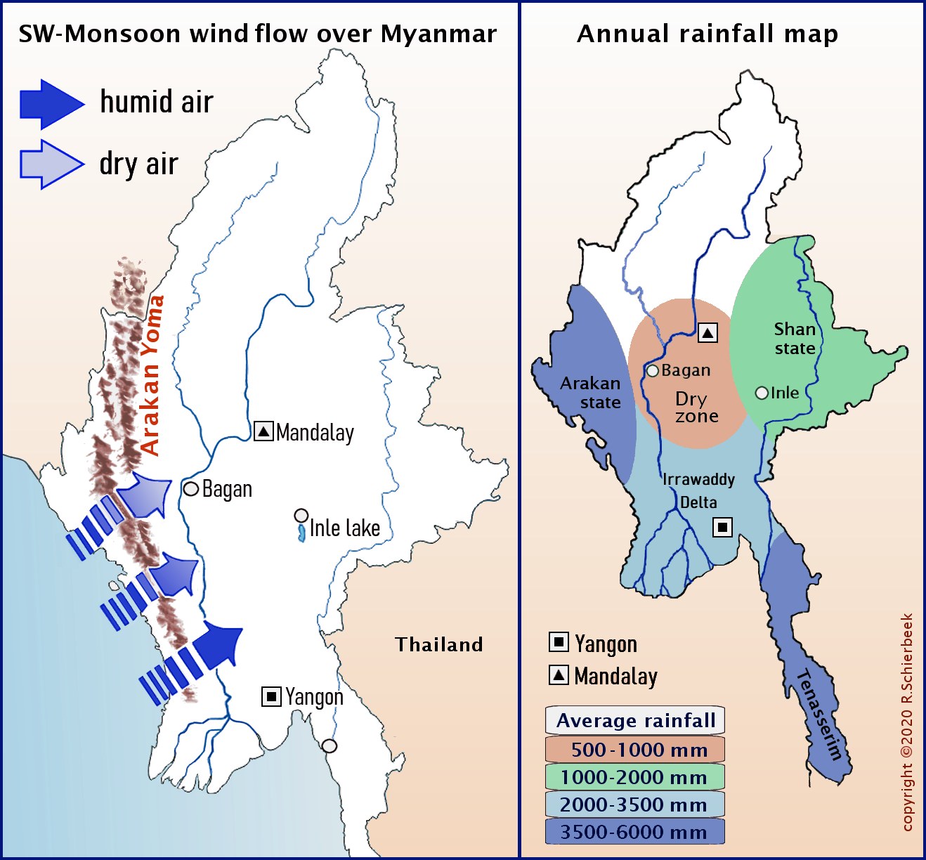
The monsoon flow over the mountain ranges.The north-south alignment of the Burmese mountain ranges creates zones of heavy and little rainfall during the southwest monsoon. The rain shadow effect from the Arakan Yoma (Arakan mountain range) at the western seashore is the cause of a much drier region in the center of Myanmar. This area is called the Dry Zone.
The Arakan Yoma is a major mountain range on the western side of Myanmar that blocks the monsoon wind flow. During the Southwest-monsoon the humid air from the ocean is pushed up by the Arakan mountain range; the air cools down at higher altitude (the orographic effect) and forms monsoon clouds, and huge amounts of rain fall on the coastal areas. Once inland the air has become much drier - this is the rain shadow effect in central Burma. The Irrawaddy Delta is not sheltered by mountains and thus receives the full brunt of the Southwest-monsoon.
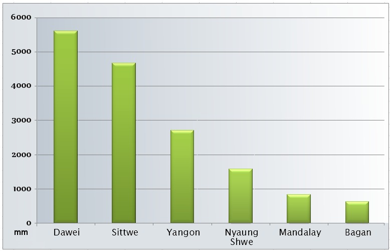
Annual rainfall in the four Monsoon zones in Myanmar.Myanmar can be roughly divided into 4 climate regions: The Dry Zone, the Coastal regions, the Shan Plateau (Shan state), and the Irrawaddy River delta. Most of the precipitation comes from the southwest monsoon winds during the summer monsoon months. Inle Lake is situated in the southern Shan State at an altitude of 900 meters and has a typical mountain climate. From November to February temperatures drop sharply at night to below 10 degrees Celsius. Mornings are quite cool but around 10 am quickly warm to the usual tropical temperatures of over 25 degrees Celsius.
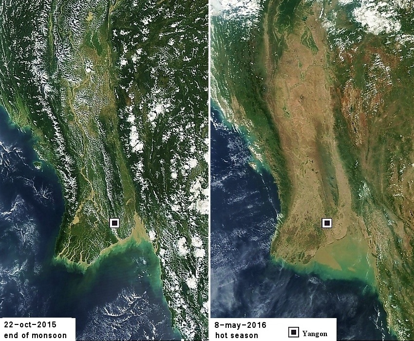
These two satellite photos show the vegetation difference between the hot season and the end of the monsoon season. The effect of the mountains on the rainfall is obvious, as is the central Dry zone.
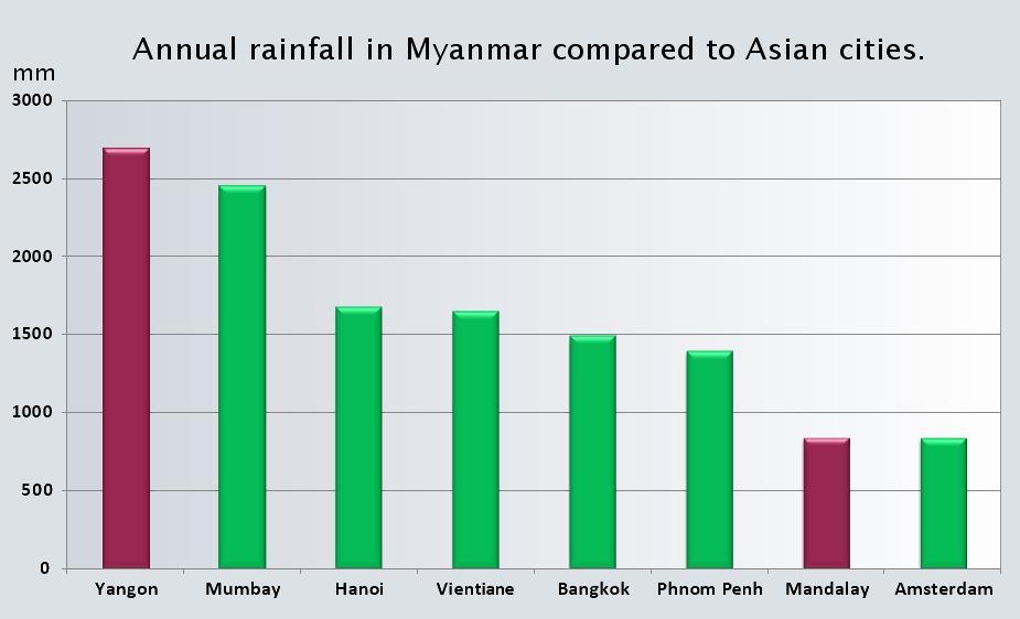
How dry is the Dry Zone?How dry is the Dry Zone? As the graph below shows, the annual precipitation in Mandalay is about the same amount as that in Amsterdam. Except in Amsterdam, it can rain the whole year but in Mandalay it falls in less than six months. Yangon is super-wet compared to most monsoon area cities like Phnom Penh, New Delhi and Vientiane, but Mandalay gets much less rain. Yangon gets more than three times the yearly rainfall than Mandalay (2700 mm versus 830 mm); see the graph below. The Dry Zone is the official name, but the correct term for the central area would be the "Much Drier zone." The Dry Zone is only really dry in winter - just like the rest of Myanmar. Then, as the hot season starts, the dry zone very slowly becomes a semi-desert, and Bagan becomes a sandy plain between thousands of stupas. The monsoon reverses this trend, and towards the end of the monsoon the plains and rice fields turn bright and green. Lastly an interesting fact: the old capitals of Burma like Bagan, Ava and Mandalay were founded in the central dry region; but for obvious reasons they are all on the banks of the largest river of Myanmar, the Irrawaddy. The river would have been essential for irrigation and transport. The first king of Bagan, King Anawrahta, was a prolific dam- and canal-builder, and managed the irrigation of the Dry zone with water from the Irrawaddy and Zawgi river. Thereby, he changed Upper Burma into a significant rice growing area, and also introduced Theravada Buddhism there.
Myanmar gets on average much more rain than Thailand, and that is because of the effect of mountains on the monsoon rains. Mandalay and Bagan however get much less rain than most towns in Myanmar, because they are situated in the dry zone.
Tropical diseases during the monsoonThe monsoon has not only a transforming effect on the landscape, it also influences the wildlife and ... the mosquitos. Plants with fresh greenery appear, snakes escape flooded fields and search higher ground in the villages, and mozzies start their happy buzzing in search of prey. During the fierce fighting between the Japanese and allied forces in WW2 many casualties were caused by tropical diseases like malaria, beriberi and dysentery. The summer monsoon brings rain and warm weather - perfect conditions for mosquitos. Because of the monsoon Dengue fever and malaria are seasonal; though there are always some mosquitos even in winter. For Myanmar, the recommended basic vaccinations are DTP (Diphtheria-tetanus-polio), Hepatitis A, and Typhoid vaccine. The Rabies vaccine is optional, there are pre-exposure vaccinations available, which do not provide full protection. In case of a dog-bite you will still need to see a doctor. A full course of pre-exposure vaccines simplifies and shortens the course of post-exposure treatment. More on Rabies and post-exposure treatment (PEP) below. Hepatitis B is very different from Hepatitis A. Hepatitis B is spread through blood, semen, or other body fluids from a person to person, and is thus easily avoided. There are long-term vaccines available against Hepatitis, one of them is Twinrix. Twinrix is a vaccine which protects against Hepatitis A and B; it is a mixture of two earlier vaccines. Malaria - Monsoon season means more mozzies.The chance of catching malaria is very small during the winter season because your chance of getting mosquito bites is quite low. If you visit rural areas (e.g. trekking) or jungle areas the chance of mosquito bites and malaria is higher. The malaria risk assessment by the US, the UK and French authorities is dissimilar, and they usually do not take the monsoon into account:
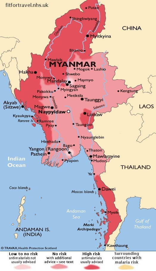
So, it seems that the malaria risk assessment is not hard science; but more like an educated guess by each countries' health authority. The map of Myanmar below shows the areas where malaria is endemic; and endemic means: the disease is permanently present in a certain area. An epidemic on the other hand, is the start of a quickly spreading disease, if it spreads worldwide it is called a pandemic. Essentially, endemic means it is confined, epidemic means it is an outbreak.
Note that this map corresponds roughly with the Average annual rainfall map. Mosquitos need fresh water to reproduce, and Rakhine state in the west and Tenasserim/Tanintharyi state on the southern coast get lots of rain during the monsoon. There is a direct relation between malaria transmission and high rainfall areas. Ngapali beach seems to have a higher malaria risk, because mosquitos are present year-round. The coastal zone of Arakan/Rakhine gets massive amounts of rain and has plenty of water for mozzies to breed in even in the dry winter season. The flat area between the beach and the mountains, one or two kilometers wide, has many lakes and swamps, and this is where those mosquitos breed.
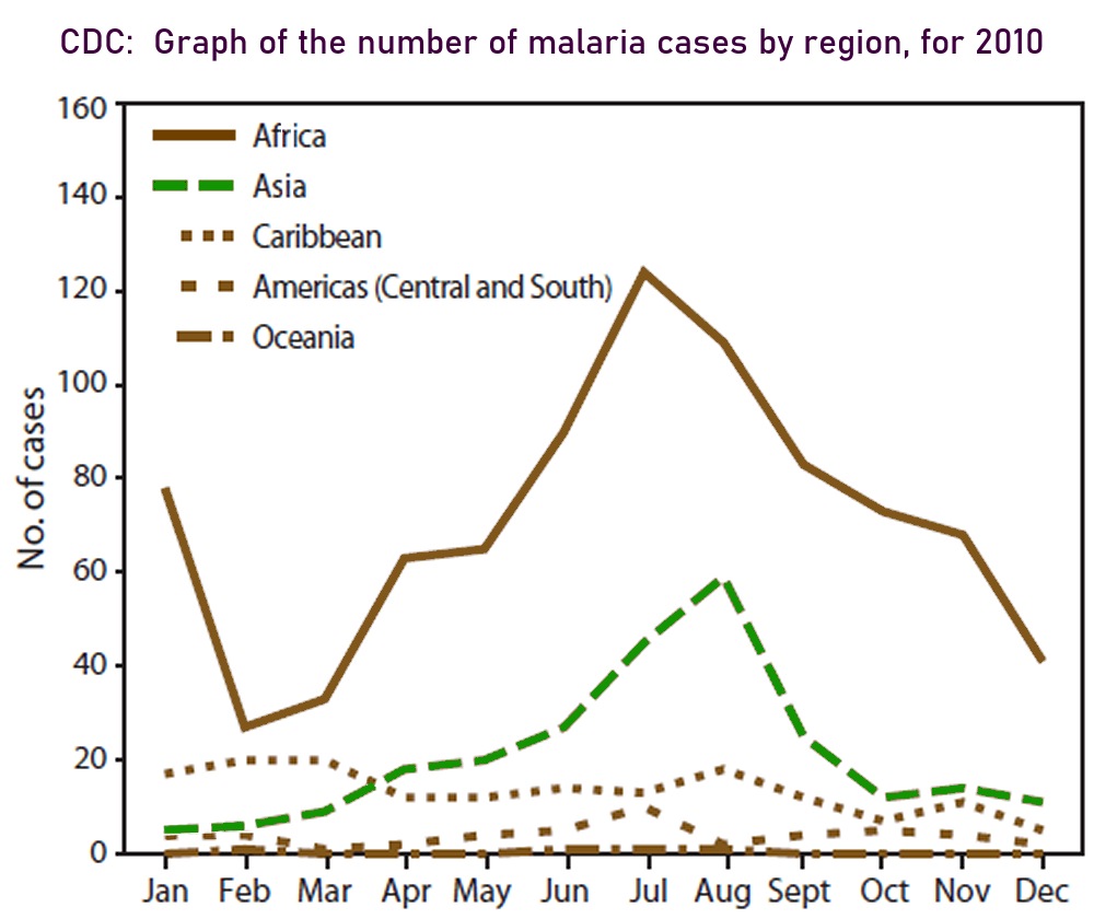
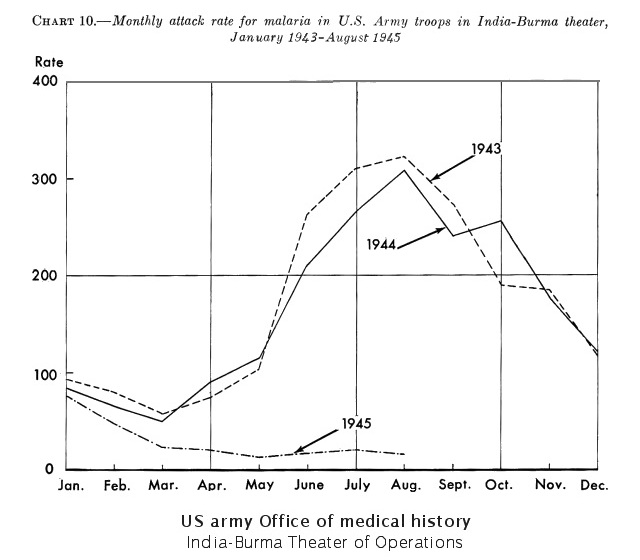
In short: malaria depends on the weather and is seasonal in Myanmar. Monsoon season means more mozzies! Even in the second world war the experts knew that malaria is seasonal - see the chart below. And if you are travelling during the monsoon, after nightfall, when the mozzies start humming; it is smart to "spray and cover up". The chance of catching it is also higher in endemic areas like jungles and swamps, and in high rainfall areas.
Some people always get mozzie bites no matter what; in that case just get the malaria pills. If you go trekking, sleep in very cheap guesthouses or homes, get drunk and wake up in the local park, or are a mosquito magnet then take all the stuff you doctor advises you. Do plenty of research on vaccinations and consult a travel doctor before you travel to Myanmar. Myanmar does not have the modern hospitals of Thailand, and it used to have a higher malaria rate than its neighbors, especially in the mountainous, remote western areas of Rakhine and Chin state. But there are currently several succesful programs for malaria prevention, and eventual elimination by 2030. In the last ten years Malaria cases in Myanmar have dropped quickly, see more: www.rfa.org ( RFA, Radio Free Asia, 1-11-2018: Malaria cases in Myanmar see huge drop). Bottom line: you are more likely to catch a food-borne disease (dysentery, typhoid fever, traveler's diarrhea) in Myanmar, than in Thailand. Avoid fish if it is not local, I believe the necessity of keeping fish fresh is often not understood and practiced. For example, seafood and fish poisoning (fish, shellfish, prawn, shrimps) seems to be quite common in Myanmar. Fish is often cooked just a very short time, which may not be long enough to kill any pathogens.
Myanmar: a high rabies endemic country.Myanmar is classified by the World Health Organization as a "high rabies endemic country." Myanmar's dog population is about 4 million; and an estimated 600.000 people are bitten annually. In a Buddhist country like Myanmar, people are generally against the killing of any animal. That is why there are now about four million dogs in Myanmar, and 70 percent of them are strays! Rabies is now more common than malaria, with around 600.000 bites and 1000 deaths every year. While the number of cases of rabies have actually remained stable over the past few years, prevention for malaria has drastically improved. Municipal authorities in Myanmar's larger cities are culling the dogs regularly, with Yangon city killing about 2500 dogs each month. However, in smaller towns this is not the case. For example, in Nyaung Shwe, Inle lake, there are too many stray dogs; and sometimes at night you will hear a few dogs howling. The small villages around Inle lake used to solve their stray dog problem by putting the dogs on a boat and moving them to the other side of the lake. However, the opposite village usually repaid the compliment by reversing the operation. It appears many dogs have now ended up in the main town, Nyaung Shwe. Rabies is a 100% fatal disease but at the same time 100% preventable. If you get bitten, you should go to a hospital within 24 hours. The post-exposure treatment (PEP - post-exposure prophylaxis) should start as early as possible after exposure, preferably within 72 hours. The PEP treatment is available in Yangon but not in small towns and villages. For example, Nyaung Shwe has a very small hospital with few or no English speaking staff, so it is probably best to avoid it. In Yangon or Bangkok, a full course of the PEP vaccine treatment costs around $200 including consultation; it is administered over a period of three weeks. For a dog bite a Tetanus vaccination is also required.
The Rabies catch-22.If you are bitten by a dog, it is possible to just observe the dog for 10 days and see if it develops symptoms. However, the catch-22 is that it is compulsory to start treatment immediately after a bite. Also; observing the dog for 10 days may not be long enough. And by the way, rabies is also endemic in other south-east asian countries, like Cambodia.
Burmese Toponymy - Colonial name glossary.In 1989 the name Burma was changed to Myanmar and many other British colonial town names were changed - with the exception of Mandalay. This is a list of changes from the old colonial names to the new Myanmar names.
British colonial name - Myanmar name: old name - new name
Akyab - Sittwe (Sittway)
Amherst - Kyaikkami (Kyaik-kami)
Ava - Innwa / Inwa
Bassein - Pathein
Bilugyun - Bilu Kyun, meaning Ogre island
Demoso - Demawso (Kayah state)
Fort Herz - Putao
Gokteik - Gokhteik (also: Goke theik, Goteik)
Thibao - Hsipaw (also: Thipaw, Thibaw)
Kyaukme - Kyaukme (pronounced ChowkMei)
Kengtung - KiangTung (also:
Chiang Tung, Kyaing Tong, Kyine Tone)
Kyaik Htee Yoe - Kyaiktiyo (near Golden Rock pagoda)
Magwe - Magway
Maymyo - Pyin U Lwin (also: Pyin Oo Lwin)
Martaban - Mottama
Mergui - Myeik
Moulmein - Mawlamyine (also: Mawlamyaing)
Mt. Victoria - Nat Ma Taung
Myohaung* - Mrauk-U (pronounced Myow Oo) *Myohaung means old town.
Pagan - Bagan
Pegu - Bago (pronounced Peh kou)
Prome - Pyay
Rangoon - Yangon
Sandoway - Thandwe
Tavoy - Dawei
Toungoo - Taungoo (Bago region)
Taungup - Taunggok (Rakhine state)
Victoria Point - Kawthaung
Yawnghwe - Nyaung Shwe
|
|
"Mandalay for the speaking, Yangon for the bragging, and Mawlamyine for the eating".
About the author: aboutme.htm
| |||||||||||||||||||||||||
